Hi all! I wish I had found this site ages ago. I have always dreamed of having a pond and I've spent the past couple weeks browsing through the forums trying to learn as much as I could. Unfortunately, I'm not sure if my property is fit for a pond due to it's elevation and hills.
The land is just shy of 100 acres, located about an hour west of St. Louis, Missouri. It's currently all forrest land with a couple creeks running through it and it's relatively hilly. I have attached a topography map and terrain map.
I love fishing, but the main use would be swimming and recreation, so I would like the pond to be as big as is feasible. Based on the maps below, does anyone have any suggestions or input on whether a pond is possible on this property?
(P.S., I considered putting this in the "Selecting a Site" forum, but since this land is my only option, I thought this was a more appropriate place to post. My apologies if I was incorrect)
My dream pond system would be to have a main pond the the lowest level. With feeder ponds that all run down into the main pond eventually.
Each pond would have different size grates and different fish. I would have a walleye pond as the main pond, that is fed by a perch pond, that is fed by a shiner pond.
Striped Bass, welcome to the forum, from a fellow Missourian. My dream was always to build a three acre pond. For some reason, that was, to me, the ideal size. My property didn't have the right layout for anything more than one acre. We have found it to be fine. When you add in all the labor or seeding, mowing, cleaning up, etc. there are times when I'm glad one acre was the max. The guys from the Mo Dept of conservation came out to my place, after I had a backhoe come out to dig test holes. (They are in the USDA office.) He had a computer program that calculated watershed, and figured one acre was my max. He also had a soils guy with him that evaluated the clay. They gave me a probability of success that I could live with. I still spent way too much money, and I'm still fighting a small leak, but I really love having the pond. If you are out around Herman MO, I see a lot of ponds out that way that all seem to be holding water fine.. I hope one of the real experts here will jump in and give you more sound advice. Edit, this is what my ground looked like before construction..
9 yr old pond, 1 ac, 15' deep. RES, YP, GS, FHM (no longer), HBG (going away), SMB, and HSB (only one seen in 5 yrs) Restocked HSB (2020) Have seen one of these. I think that's about all I should put in my little pond. Otter attack in 2023
Hi all! I wish I had found this site ages ago. I have always dreamed of having a pond and I've spent the past couple weeks browsing through the forums trying to learn as much as I could. Unfortunately, I'm not sure if my property is fit for a pond due to it's elevation and hills.
The land is just shy of 100 acres, located about an hour west of St. Louis, Missouri. It's currently all forrest land with a couple creeks running through it and it's relatively hilly. I have attached a topography map and terrain map.
I love fishing, but the main use would be swimming and recreation, so I would like the pond to be as big as is feasible. Based on the maps below, does anyone have any suggestions or input on whether a pond is possible on this property?
(P.S., I considered putting this in the "Selecting a Site" forum, but since this land is my only option, I thought this was a more appropriate place to post. My apologies if I was incorrect)
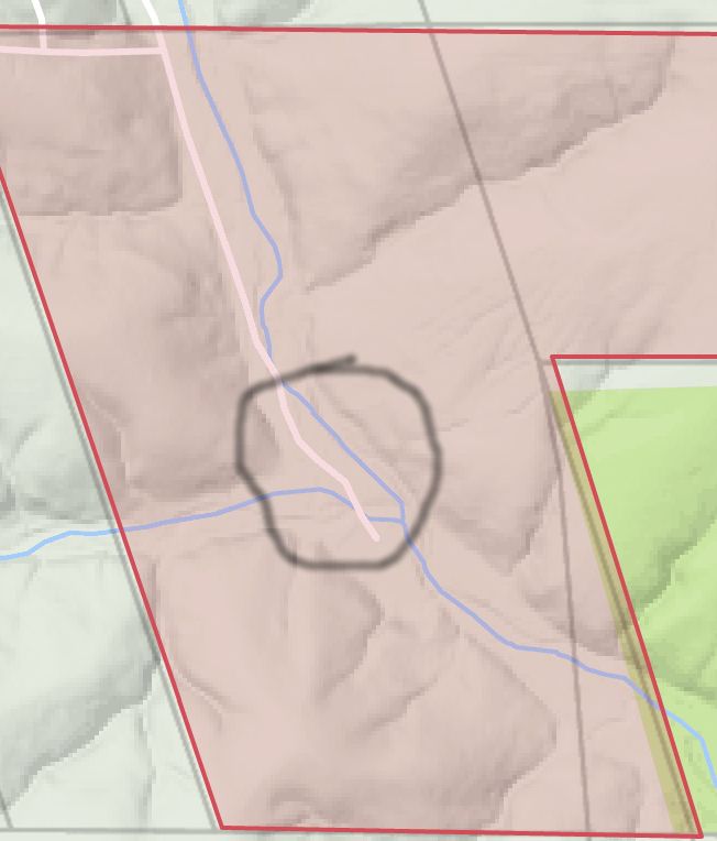
I would look in this area, or depending on the water flow of those streams, the area just above this circled area (so you get only one stream inflow versus two in the circled area.
Considerations: - Are you allowed to do anything to those streams from your DNR point of view - can you dam them, divert them, etc., and if you do, does that give DNR authority over the body of water you create?
- What is the runoff potential due to the topography?
- Since your primary goal is that of swimming clear water is what you seek I imagine. If so, you'll want deep water to cut down on the plant life, especially near the banks. A lot of folks prefer the gradual slope so that if someone falls in they can walk or crawl out. I inherited a pond wherein 3/4 of the banks are drop offs. You step off the bank into 8 or 14 feet of water straight down.
Welcome SB...I am NO expert, just a PB member that likes to talk ponds, but I have attached a modified copy of your topo that will help in the conversation in the least and I have put my first take on the areas I would concentrate on.
Area "A" gives the most flexibility and keeps the pond/lake centrally located and entirely on the property. It also allows for the widest range of budgets. You could go from the smallest of ponds up to about 20-25 acres. The red lines (1 thru 4) give simple examples for dam locations that line up with the topo lines so that you can see the basic pond shape.
Areas "B" and "C" are poor secondary locations, but could be considered if area "A" is a no-go for whatever reasons (potential house location, poor soil conditions, endangered species home, etc).
There is a ton of things to consider and get expert help with. I have merely taken a glance at your property, pretended it was mine, and threw I my two cents.
Edit - looks like BL beat me to the punch. It's funny how two different people can see two completely different takes on the same topic. Enjoy the diversity!
I'm back. After looking at both the options that BL and I have offered...
My "A" option may be restricted by watershed. A large pond in area "A" may not be possible due to the limited watershed while BL's option may require a fair amount of digging to yield good depth and remain on the property. The creek also needs to be evaluated as the watershed that feeds the creek may be enormous causing dam topping on a regular basis.
I'll throw this out as someone who didn't do a really good job in this area - make sure you size the watershed - NRCS can help with that - and make sure you plan everything for higher than average - width of levee, size of culvert, size of emergency spillway, etc.
Ask me how I know. I tried to go on the cheap on a couple of things and have spent a ton of time and money since then regretting it. I'm right now looking at replacing my culvert, which is going to cost me twice as much as just sizing it correctly (bigger) the first time.
Dale
"When tempted to fight fire with fire, remember that the Fire Department usually uses water." - anonymous
A couple of thoughts on the blue lines: 1. They will carry in critters, fish, and fertilizer runoff, all of which will be outside of your control. 2. Real problems during flooding, causing you some high expenses trying to design around. 3. Silt and debris from farming, construction, etc will age/fill your pond much faster than you may like.
Quarter-Acre's 'A' suggestion would be the lowest cost, least risk location IMHO, since less dirt needs to be moved that anywhere else. Just size it accordingly to the runoff that depression will receive. You may be surprised how large of an area that drains and how big the pond will be. You always have the option of pumping water up from the creek during dry spells.
Of course us forward thinking folks would say "Build option 'A' first, then build the big one across the creek once the financial committee gets over the shock of the cost.
My dream pond system would be to have a main pond the the lowest level. With feeder ponds that all run down into the main pond eventually.
Each pond would have different size grates and different fish. I would have a walleye pond as the main pond, that is fed by a perch pond, that is fed by a shiner pond.
Hoo ya..... just thinking out loud.
That would be one heck of a pond system. The idea is there, now all I need is to win the lottery
Originally Posted By: SetterGuy
Striped Bass, welcome to the forum, from a fellow Missourian. My dream was always to build a three acre pond. For some reason, that was, to me, the ideal size. My property didn't have the right layout for anything more than one acre. We have found it to be fine. When you add in all the labor or seeding, mowing, cleaning up, etc. there are times when I'm glad one acre was the max. The guys from the Mo Dept of conservation came out to my place, after I had a backhoe come out to dig test holes. (They are in the USDA office.) He had a computer program that calculated watershed, and figured one acre was my max. He also had a soils guy with him that evaluated the clay. They gave me a probability of success that I could live with. I still spent way too much money, and I'm still fighting a small leak, but I really love having the pond. If you are out around Herman MO, I see a lot of ponds out that way that all seem to be holding water fine.. I hope one of the real experts here will jump in and give you more sound advice. Edit, this is what my ground looked like before construction..
Thanks for the info Jeff. I enjoyed your photo album and your pond looks great. How difficult was it to get the Conservation department to come out and evaluate your clay/watershed?
Originally Posted By: basslover
I would look in this area, or depending on the water flow of those streams, the area just above this circled area (so you get only one stream inflow versus two in the circled area.
Considerations: - Are you allowed to do anything to those streams from your DNR point of view - can you dam them, divert them, etc., and if you do, does that give DNR authority over the body of water you create?
- What is the runoff potential due to the topography?
- Since your primary goal is that of swimming clear water is what you seek I imagine. If so, you'll want deep water to cut down on the plant life, especially near the banks. A lot of folks prefer the gradual slope so that if someone falls in they can walk or crawl out. I inherited a pond wherein 3/4 of the banks are drop offs. You step off the bank into 8 or 14 feet of water straight down.
Originally Posted By: Quarter Acre
Welcome SB...I am NO expert, just a PB member that likes to talk ponds, but I have attached a modified copy of your topo that will help in the conversation in the least and I have put my first take on the areas I would concentrate on.
Area "A" gives the most flexibility and keeps the pond/lake centrally located and entirely on the property. It also allows for the widest range of budgets. You could go from the smallest of ponds up to about 20-25 acres. The red lines (1 thru 4) give simple examples for dam locations that line up with the topo lines so that you can see the basic pond shape.
Areas "B" and "C" are poor secondary locations, but could be considered if area "A" is a no-go for whatever reasons (potential house location, poor soil conditions, endangered species home, etc).
There is a ton of things to consider and get expert help with. I have merely taken a glance at your property, pretended it was mine, and threw I my two cents.
Edit - looks like BL beat me to the punch. It's funny how two different people can see two completely different takes on the same topic. Enjoy the diversity!
Bass Lover and Quarter Acre: Thank you both so much for taking the time to edit the topo map. My original thought was to build it where Bass Lover circled, where the creeks come together. However, I'm starting to wonder if damming up the creek will cause too many issues and be met with too many regulations, which makes me lean more towards Quarter Acre's "A" pond. Below is a photo of the creek after it rained. Does it appear to be moving too much water to be rerouted/changed without running into restrictions?
Originally Posted By: dlowrance
I'll throw this out as someone who didn't do a really good job in this area - make sure you size the watershed - NRCS can help with that - and make sure you plan everything for higher than average - width of levee, size of culvert, size of emergency spillway, etc.
Ask me how I know. I tried to go on the cheap on a couple of things and have spent a ton of time and money since then regretting it. I'm right now looking at replacing my culvert, which is going to cost me twice as much as just sizing it correctly (bigger) the first time.
Good to know. Once I get a little better idea of locations I think might be good for a pond, I'll see if I can get someone from the NRCS to come out.
Originally Posted By: liquidsquid
A couple of thoughts on the blue lines: 1. They will carry in critters, fish, and fertilizer runoff, all of which will be outside of your control. 2. Real problems during flooding, causing you some high expenses trying to design around. 3. Silt and debris from farming, construction, etc will age/fill your pond much faster than you may like.
Quarter-Acre's 'A' suggestion would be the lowest cost, least risk location IMHO, since less dirt needs to be moved that anywhere else. Just size it accordingly to the runoff that depression will receive. You may be surprised how large of an area that drains and how big the pond will be. You always have the option of pumping water up from the creek during dry spells.
Of course us forward thinking folks would say "Build option 'A' first, then build the big one across the creek once the financial committee gets over the shock of the cost.
Excellent insight. I didn't think about the silt/debris. It looks like "A" is the current front runner.
SB said, "Thanks for the info Jeff. I enjoyed your photo album and your pond looks great. How difficult was it to get the Conservation department to come out and evaluate your clay/watershed?"
They were great to work with. The guys I worked with were in the NRCS office. Someone else also mentioned them.
They originally came out thinking I was looking for funding for the pond. Once I explained the pond was going to be in the timber, he said he couldn't help with funding. I guess if I would have built in the open fields, it would have had an erosion angle for state reimbursement. I wanted to build it in the woods anyway. Your local conservation officer's office can get you all the phone numbers. Good luck.
9 yr old pond, 1 ac, 15' deep. RES, YP, GS, FHM (no longer), HBG (going away), SMB, and HSB (only one seen in 5 yrs) Restocked HSB (2020) Have seen one of these. I think that's about all I should put in my little pond. Otter attack in 2023


![[Linked Image from corvettejunkie.com]](http://www.corvettejunkie.com/pb.gif)


![[Linked Image from i90.photobucket.com]](http://i90.photobucket.com/albums/k247/jmilczski/Fish/PBSubscribe.gif)


