|
Forums36
Topics40,963
Posts557,991
Members18,503
| |
Most Online3,612
Jan 10th, 2023
|
|
|
7 members (bmicek, nvcdl, jmartin, Sunil, Dave Davidson1, Fishingadventure, FishinRod),
1,200
guests, and
566
robots. |
|
Key:
Admin,
Global Mod,
Mod
|
|
|
|
Joined: May 2008
Posts: 30
Lunker
|
OP

Lunker
Joined: May 2008
Posts: 30 |
Hi,
We recently purchased a house on five acres in northwest Virginia which has a perfect structural location for a pond. It is already naturally sloped on both sides, and has a seasonal run-off down the middle from a wet-weather spring through the watershed. Plentiful water.
Today I received the soil survey for Frederick County (our county), and the exact location for the pond is designated as Weikert soil. My understanding is that this is primarily a fine particle shale loam (yellowish).
Is this type of soil unsuitable to build a pond in? Can it be compacted to retain water(I understand it has little plasticity)? Less than a mile up the road is a nice pond which the soil topography map lists the same as mine (Weikert).
Thanks in advance. If we can proceed (which would be immediately), I will definitely post pictures here.
Last edited by DCox; 07/11/08 01:59 PM.
|
|
|
|
|
Joined: Apr 2003
Posts: 1,097 Likes: 18
Lunker
|
|
Lunker
Joined: Apr 2003
Posts: 1,097 Likes: 18 |
DCox, your best bet is to get topo/satellite maps of your region, go to : http://www.acme.com/planimeter/and zero in on your location. The satellite shots will assist you with ponds in your area, if you see nearby ponds, likely the same substructure is holding water. the topo maps will help you calculate runoff needed for your pond size.
|
|
|
|
|
Joined: Oct 2005
Posts: 6,934 Likes: 2
Ambassador
Field Correspondent Lunker
|
|
Ambassador
Field Correspondent Lunker
Joined: Oct 2005
Posts: 6,934 Likes: 2 |
Ya'll correct me if I'm wrong (this would be a natch for Ed Eitel)...
The names given to soils are based on regional strata findings. The names we see in Illinois are named something completely different in Texas for a similar soil type.
....or not.
???
|
|
|
|
|
Joined: Oct 2005
Posts: 6,934 Likes: 2
Ambassador
Field Correspondent Lunker
|
|
Ambassador
Field Correspondent Lunker
Joined: Oct 2005
Posts: 6,934 Likes: 2 |
Hey DCox...welcome to the PB forum. Glad ya made it! - Your NRCS div of the USDA should be able to provide data about the various soils and their compositions. If you dig drill deep enough in the VA NRCS website, you will find the same. start here
|
|
|
|
|
Joined: May 2008
Posts: 30
Lunker
|
|
OP
Lunker
Joined: May 2008
Posts: 30 |
Thank you so much for the replies. They are actually very encouraging. I was seriously disappointed when I received the soil survey today in the mail from Frederick County, as the Weikert soil profile it shows for this portion of my property doesn't look anywhere near as good as what I have seen elsewhere. However, the survey map showed precisely the same soil in existing ponds just up the road (all within 1/4 - 3/4 mile), and all within the same profile or disposition of the land. 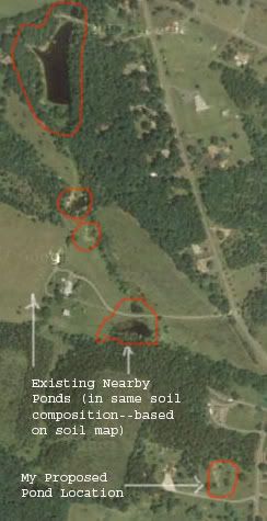 I think I will go and pay a visit to these current pond owners tomorrow and see if they have any helpful information. If all looks good, I would like to get things going very soon.
|
|
|
|
|
Joined: Nov 2004
Posts: 1,074
Lunker
|
|
Lunker
Joined: Nov 2004
Posts: 1,074 |
DCox
Welcome aboard.
Check with tour neighbors, see if your soil is the same. Take a shovel, and some of you dirt to make sure they are the same.
If the digging is not to hard you could also dig a hole on your place fill it with water and see what happens.
OTTO
|
|
|
|
|
Joined: Oct 2005
Posts: 6,934 Likes: 2
Ambassador
Field Correspondent Lunker
|
|
Ambassador
Field Correspondent Lunker
Joined: Oct 2005
Posts: 6,934 Likes: 2 |
DCox,
Soil sample maps are a decent snapshot of what you have, but they are definitely NOT the bottom line. As I recall, most all sampling was done some 30 - 50 years ago. It was done with somewhat primitive equipment; a probe that goes no deeper than 60". It is entirely possible that different soils lie below this sampling layer.
Your plan to interview neighboring pond owners is a component of the ABC's of planning; good decision. While there, ask if they remember the builder of the pond. Also, what type of water level changes they see thru the different seasons and if there is any inflow of spring or pumped water (that they know of). The obvious goal is to get a pulse on their water loss beyond normal evaporation.
Another good source of info, should it be available, is the water well drilling records in your immediate area. In some states, this information is available on-line. It takes some drilling (ooops) into the state's website to find it; usuallly within the DNR section/ground water. It will show all the reported wells and the soils encountered during the drilling process and their depth.
-
BTW, are you above or below the direction of water flow of the other depicted ponds? And...are there other ponds south of your proposal that are within the same focused watershed? Just thinking about how much control you will have over how much watershed for your particular project.
|
|
|
|
|
Joined: May 2008
Posts: 30
Lunker
|
|
OP
Lunker
Joined: May 2008
Posts: 30 |
Otto,
Thanks for the tip on bringing some soil to the neighbors in hand. I may have to ultimately answer this question with some large holes in the ground to inspect the layers and see if water holds.
Brettski,
Thankfully our property is above those ponds north of us, and there is a natural ravine which breaks east and dumps into the local Opequon Creek about 1/8 mile away. Otherwise I wouldn't even consider it given the potential deluge. A couple weeks ago I chatted about the well of our next door neighbor and what he came up with. I am going to look into the records you mention to get a more accurate sense of what is going on.
Again, thanks for your help. I will keep you updated on my progress if you are interested.
|
|
|
|
|
Joined: Oct 2005
Posts: 6,934 Likes: 2
Ambassador
Field Correspondent Lunker
|
|
Ambassador
Field Correspondent Lunker
Joined: Oct 2005
Posts: 6,934 Likes: 2 |
...I will keep you updated on my progress if you are interested. Very much so...thats' what Pond Boss is all about.
|
|
|
|
|
Joined: May 2004
Posts: 13,974 Likes: 277
Moderator Lunker
|
|
Moderator Lunker
Joined: May 2004
Posts: 13,974 Likes: 277 |
DCox, even if soil maps were not promising, I would not give up on a pond dream without bringing in a backhoe or deep auger for a series of test holes. If the subsurface results are definite and negative, then you will know for sure.
And can start pricing liners or hauling clay form elsewhere (hopefully on site)
"Live like you'll die tomorrow, but manage your grass like you'll live forever." -S. M. Stirling ![[Linked Image from i.pinimg.com]](https://i.pinimg.com/736x/ed/b5/e7/edb5e7f935843b996cf52be593c9ebd2--smoothie-smooth-collie.jpg)
|
|
|
|
|
Joined: May 2008
Posts: 30
Lunker
|
|
OP
Lunker
Joined: May 2008
Posts: 30 |
Well, I spent the better part of today searching for answers, and here is what I found so far: On the picture I posted above, I was able to talk with the owners of the largest pond. They had it dug ca. 27 years ago and it is over 20 feet deep. The topography was a gully (like my site), with the same Weikert shale/silt. When I inquired about the core and needed clay, the owner mentioned that the contractor found clay below the topsoil and above the Weikert shale. In fact they had enough to do the entire dam. There are no feeder streams, just watershed. He did mention that it does seem to leak some, but once it goes down to a certain level, it goes no further. Since they did not line the basin with clay, but just compacted with the dozer, my guess is the water likes to wick through some of the shale. He said the dam does not leak. With this news in hand, I went home and grabbed a shovel to see what lay beneath. I dug right about where I estimate the core will be. The topsoil is some typical silt, about 4-6" thick. Right beneath it (at least where I was digging) was a strip of very nice clay that ran about 4" thick. Here is what it looks like when I rolled it out (quite a bit of plasticity): 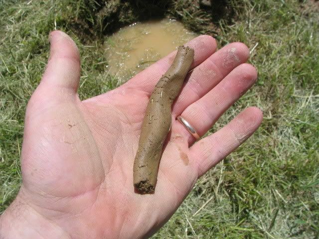 Directly beneath this strip of clay is the Weikert shale I had heard so much about. The stuff really is not as bad as I had expected, though left uncompacted it surely would drain. But notice what it does when it is semi-moist (but not too much): 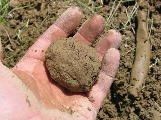 It held a ball form pretty good, though certainly not as good as the clay. Moreover, it has to have some water to compact like this, but not too much, otherwise the fine materials disperse and you are left with a handful of aggregate. Encouraged by this, I dug a hole about 2.5-3 feet deep. At that point water was seeping in through the sides at certain points (the soil is still wet down there from rains last week). So I filled the hole to the top from a stream and went back to mowing: 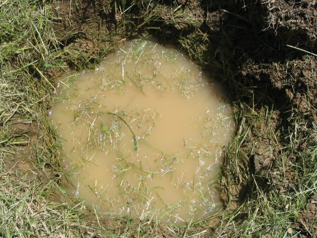 I was disappointed to come back within the hour and find that the water was dropping significantly. Perhaps I am just spinning this in too positive a light (wishful thinking?), but I am hoping that it was wicking into the top-soil. I think it is more likely that it is flowing out through this Weikert soil (which explains why the water was also immediately seeping into the hole). In any case, it still begs the question of whether I can compact this material firmly in a basin so that the leakage would be minimal. I am still entertaining this notion to keep the dream alive. It seemed to have worked with the people up the road 27 years ago. Anyway, here are some shots to give you an idea of what I have in mind in terms of the layout: This first one is toward the rear of the proposed site, with a line drawn across to give an idea of where the core/embankment would be. Down the middle is a depression where the seasonal run off flows (it is a small creek right now, but it dries up): 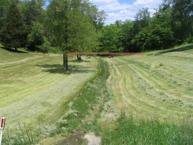 This next pic shows the gully from above. It really does not do justice to how deep down this gully is: 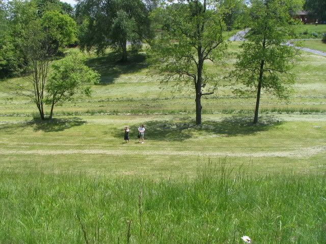 Here is a comparable shot from the other side, toward where the pond would meet the driveway: 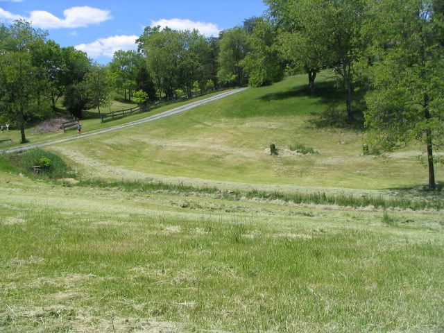 If this first pond works out, on the opposite side of the driveway is the feeder spring (which flows through the culvert). This would be a beautiful spot for another small pond (it has alot of nice shade trees. Good place for the kids to catch frogs): 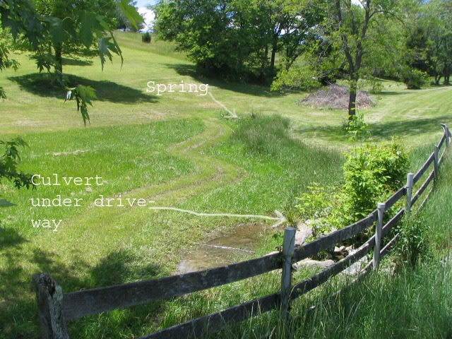 Just to the left of the spring is an old abandoned hand-dug well (which is currently full of water), which I will either excavate with the second pond, or just fill in: 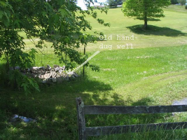 But again, if all goes well with the first pond, I would like to do the second. They would be attached to one another through the two concrete culvert pipes under the driveway. Here is a birds-eye shot of our whole five acres with the proposed pond outlined in red: 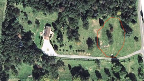 I guess the next step is to take my tractor and strip off a good patch of this top-soil and see if that layer of clay is consistent throughout. If it is, I do believe I would have enough to build the core. I guess I would then proceed on the hope that this Weikert soil can be compacted good enough in the basin to provide an adequate seal. At least that is my hope.
|
|
|
|
|
Joined: May 2008
Posts: 3
Fingerling
|
|
Fingerling
Joined: May 2008
Posts: 3 |
Great pics! Keep us posted. I am in Culpeper County and will be interested in the progress/process.
Last edited by 99fever27; 05/24/08 06:35 PM.
|
|
|
|
|
Joined: May 2008
Posts: 30
Lunker
|
|
OP
Lunker
Joined: May 2008
Posts: 30 |
Great pics! Keep us posted. I am in Culpeper County and will be interested in the progress/process. Thanks. Later today I tried to contact a recommended pond contractor in this area who is used to the local soil to set up a paid consultation before I proceed, but I cannot find the fellow in the white pages. I am going to ask around for other references on Monday. You are two counties south of where I commute to work (Loudon county). We chose to buy property as far west in the State as we reasonably could, just to get out in the country and away from the enormous taxes and severe regulations.
|
|
|
|
|
Joined: May 2008
Posts: 3
Fingerling
|
|
Fingerling
Joined: May 2008
Posts: 3 |
The same reason I live in Culpeper. Although I work in Loudoun for a construction equipment dealership. The commute does take its toll. Who is the contractor you're looking for? I may be able to help. Great pics! Keep us posted. I am in Culpeper County and will be interested in the progress/process. Thanks. Later today I tried to contact a recommended pond contractor in this area who is used to the local soil to set up a paid consultation before I proceed, but I cannot find the fellow in the white pages. I am going to ask around for other references on Monday. You are two counties south of where I commute to work (Loudon county). We chose to buy property as far west in the State as we reasonably could, just to get out in the country and away from the enormous taxes and severe regulations.
|
|
|
|
|
Joined: May 2008
Posts: 30
Lunker
|
|
OP
Lunker
Joined: May 2008
Posts: 30 |
99Fever, I sent you a PMail.
I have a question for anyone regarding the results of my test hole today . . . .
As I mentioned earlier, today I dug a hole about 3 feet deep and filled it to the very top with water. I was initially disappointed to see the water level drop significantly within the hour (ca. 4 inches); though I was extremely pleased to see a band of nice clay just sandwiched between the topsoil and the shale/silt (i.e., Weikert soil).
Some twelve hours later, and as some of you have probably experienced, I could not sleep but instead decided to get up and go check the hole with a flashlight. I was pretty much expecting to see it near empty. To my surprise, the water came down only a total of eight inches or so and is holding steady right there. It appears to be matching the water level of the seasonal run-off ditch about six feet away.
What should I make of this? Is this water level maintenance in the hole simply a reflection of the current water table level in the ground? If so, is this relevant, since I would be excavating well below that as well as including a core embankment? Since water table levels presumably change with the seasons, is the initial drop more relevant information with regard to the purposes of the test hole?
I appreciate any thoughts in trying to sort these various possibilities.
|
|
|
|
|
Joined: Oct 2005
Posts: 6,934 Likes: 2
Ambassador
Field Correspondent Lunker
|
|
Ambassador
Field Correspondent Lunker
Joined: Oct 2005
Posts: 6,934 Likes: 2 |
Is this static water level also consistent with the water in the hand-dug well?
|
|
|
|
|
Joined: Nov 2004
Posts: 1,074
Lunker
|
|
Lunker
Joined: Nov 2004
Posts: 1,074 |
DCox
Theo is right do not give up without a fight.
YES PLEASE KEEP US POSTED.
otto
|
|
|
|
|
Joined: May 2008
Posts: 30
Lunker
|
|
OP
Lunker
Joined: May 2008
Posts: 30 |
Is this static water level also consistent with the water in the hand-dug well? Thanks for the encouragement to keep exploring further. Brettski, that is an excellent question and I do not know the answer. The well is on the other side of the driveway culvert, and my test hole is on the far side of where the pond core would be. I think the total feet is ca. 250', with a bit of an elevation drop. I am going to look at it more today.
|
|
|
|
|
Joined: May 2008
Posts: 30
Lunker
|
|
OP
Lunker
Joined: May 2008
Posts: 30 |
Some updates:
I had hoped to speak with the county geo engineer or whoever today, and see how to get the process started on analyzing this shale, but forgot it was a holiday. Contacting them will have to wait for tomorrow. I am particularly interested in seeing what (if any) conditions (wetness and compaction) can make this crumbly shale into something of an impermeable barrier. If it were sand or gravel I would have pretty much given up by now, but shale is essentially just really old and well-compressed clay, so perhaps the engineers know something that can be done along these lines. We will see.
I did speak with two more pond owners up the road--one creek-fed, the other run-off (the ponds that is). They pretty much inherited the ponds, but gave some good drought and wet-season observations that will prove helpful. My Matson pond book should be in the mail any day now. I read it in the past (library copy), but decided to get one for myself.
Brettski, I checked the abandoned hand-dug well, and that thing is still full of water (which is much higher than the test-hole level). The only thing I can make of it for sure is that the well is right beside the spring and is an obvious beneficiary. Also, it should have been properly filled in a long time ago, lol.
I really like this site and appreciate the collective knowledge/wisdom of the posters. I have been spending hours on this thing, and think I am getting a little pond-obsessed, hahaha.
|
|
|
|
|
Joined: Nov 2004
Posts: 1,074
Lunker
|
|
Lunker
Joined: Nov 2004
Posts: 1,074 |
If you think this form is fun you ought to come to the conference July 11 and 12. It will make you a new man.
Hope to see you there
OTTO
|
|
|
|
|
Joined: May 2008
Posts: 30
Lunker
|
|
OP
Lunker
Joined: May 2008
Posts: 30 |
Otto or others, where can I get further info. on this conference? I am interested.
Some favorable news today on the pond. A local pond excavator stopped by my property and walked it with me. He lives in the immediate area and has built many ponds in the local soil. He looked in my test hole and immediately saw a good deal more clay than I thought I had.
Evidently, being in a gully, the soils above the Weikert shale are full of both silt and clay. Interestingly, it is laid down in successive layers; viz., there is about a four inch strip of silt, then there will be a strip of clay, then silt, then clay, and so on. He said this can go on for several feet before one hits the Weikert shale. In retrospect, it only makes sense, since the water running through this gully over long periods of time would have laid down different deposits in successive stages. Evidently, he mixes these soils together--which he calls "modular"--and that makes up the water retaining soil he uses for the core and the basin.
He is going to come Thursday morning to dig a couple of holes to see how deep this material goes, but based on his knowledge of the local area and what he has seen on my property, he is pretty well certain that a water-retaining pond can be made here.
Thursday I will post some pics of the backhoe holes and show you these various strata if you are interested.
|
|
|
|
|
Joined: Feb 2006
Posts: 1,948 Likes: 9
Moderator Lunker
|
|
Moderator Lunker
Joined: Feb 2006
Posts: 1,948 Likes: 9 |
DCox, go to pondboss.com and click on the ad that is on the right side of the page.
|
|
|
|
|
Joined: May 2004
Posts: 13,974 Likes: 277
Moderator Lunker
|
|
Moderator Lunker
Joined: May 2004
Posts: 13,974 Likes: 277 |
For a somewhat eclectic source of Conference info, as well as underwear preference data, see here. There is some very useful info from Kathy Lovell later in that thread as well.
"Live like you'll die tomorrow, but manage your grass like you'll live forever." -S. M. Stirling
|
|
|
|
|
Joined: Nov 2004
Posts: 1,074
Lunker
|
|
Lunker
Joined: Nov 2004
Posts: 1,074 |
Chris and Theo
THANKS FOR POINTING PEOPLE TO THE CONFERANCE. I JUST TAHE FOR GRANTED THAT EVERYONE KNOWS.
THANKS AGAIN
D Cox
There is no substitute for a guy on the ground that knows the area.
OTTO
|
|
|
|
|
Joined: May 2008
Posts: 30
Lunker
|
|
OP
Lunker
Joined: May 2008
Posts: 30 |
Some test holes were dug today. Needless to say, I never cease to be amazed at how much soil can change in such a short distance: Backhoe arrives: 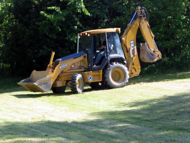 This first hole was started right behind where the core will be:  I had mixed feelings about the results of this first hole. It was not very far before we hit "black shale" as they call it here. However, they maintain that this black shale will actually hold water. There was only a small band of clay: 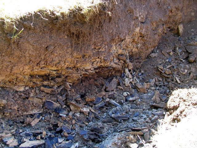 The second test hold was quite impressive. This was more forward in the first third in from the core. It was quite a bit deeper before the black shale, and had a very large depth of excellent clay: 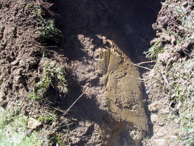 The third test hole was perhaps the most fascinating. Moving still further up the pond basin, and over to the other side, this hole was filled with eons of deposit that had run down off the adjoining hillside. It went about ten or twelve feet before hitting the black shale, and was composed of both silt and clay: 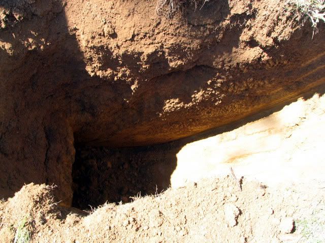 Backhoe guy waiting for instructions where to dig next: 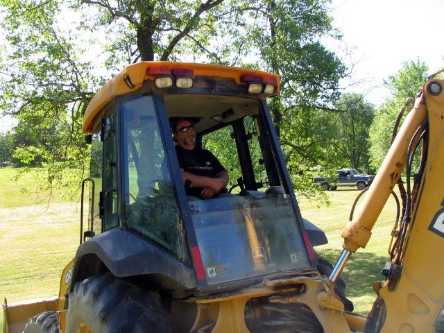 They nicely filled everything back in and smoothed it out. I could mow over where they had been: 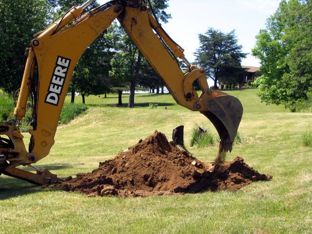 They also staked out with the laser level where the water line would be. I was very pleasantly surprised to see how much wider it was going to be (I had assumed less due to optical illusion). I have been toying with the idea of leaving these two center trees in the basin bottom, just to build a structure or fort in above the water. My chief concern is longevity and, therefore, stability and safety for the kids a little down the road: 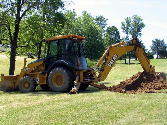 And then they leave: 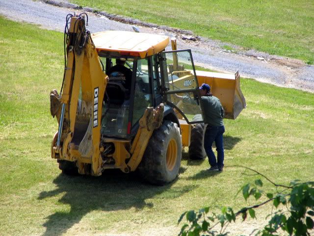 Next phase hopefully coming soon . . . .
|
|
|
Moderated by Bill Cody, Bruce Condello, catmandoo, Chris Steelman, Dave Davidson1, esshup, ewest, FireIsHot, Omaha, Sunil, teehjaeh57
|
There are no members with birthdays on this day. |
|
|
|


