|
Forums36
Topics40,991
Posts558,272
Members18,517
| |
Most Online3,612
Jan 10th, 2023
|
|
|
2 members (tim k, H20fwler),
664
guests, and
187
robots. |
|
Key:
Admin,
Global Mod,
Mod
|
|
|
|
Joined: Jun 2005
Posts: 86
Member
|
OP

Member
Joined: Jun 2005
Posts: 86 |
I figured while I am waiting on the NRCS guy to go out to the property this week, I would get a topo of the area, and see if someone can 'explain' to me what I am really looking at.  Is the 850 a depth or a location? Where range 15 and 16 are there is 'rock creek'...my place is right in there on 15/bordering 16 somewhere. My property (if I buy it) has rock creek running in the back of it. My thought was with our annual rainfall we get, run off from the main street (this area is NOT flat and in the mountains so to speak), and also I was thinking I could divert one arm of the creek or runoff to the location of the pond to keep water always there. How does this sound for an 7acre lot with a 2acre pond? Yes I understand you can't see the lot. I am under the impression there is alot of clay and rock and great soil in the general area. I also see (at least when they made the topo map that is) where oil wells are, or were....what does this mean usually as far a soil content? (more sand than clay, no sand all rock, etc) Just any kind of information might be helpful to me. Thanks again.
|
|
|
|
|
Joined: Apr 2002
Posts: 1,011
Lunker
|
|
Lunker
Joined: Apr 2002
Posts: 1,011 |
BD, The 850 you are referring to on the topo map relates to elevation and is called a contour line. A topo map uses these contour lines to give a sense of 3-D perception. Among other information on the map, you should see a title block which shows a scale (1"=xxxx feet) and the elevation between contours. Knowing these two items you can get a feel for how steep the terrain is. I'll try to give you an example. Lets say you have the following: Scale 1"=100' Elevation change between contour lines is 10' Start at a point on the 850 contour line and measure 1" (which equals 100' on the ground). Over this 100' you cross 2 contour lines (ending up on a contour line = 870). In essence this means that in the 100' you traversed, the elevation rose 20'. Applying some basic algebra means you have a 20% slope. The same applies in reverse, i.e. if you started at 850 and ended on 830. Hopefully from this example you can see that the closer the contour lines are the steeper the property is. For some really cool images, get yourself some aerial photos and a stereoscope. In fact, ask the NRCS person if he/she has photos of your property that you can view with a stereoscope. If the NRCS person doesn't know what I'm talking about,  ask for another NRCS person. Can't address the issue of oil wells. The only "oil well" I'm familiar with is attached to a nozzle and is pumping out go juice at around $2.35 / gallon. Hope this helps. Russ
|
|
|
|
|
Joined: May 2004
Posts: 13,985 Likes: 281
Moderator Lunker
|
|
Moderator Lunker
Joined: May 2004
Posts: 13,985 Likes: 281 |
BD: My 2 cents worth
The (reddish) brown lines, labelled with the same-colored numbers like "850,", are contour lines - they show the elevation. So, everywhere on the "850" line is 850 feet (unless it's in meters, which I doubt, but you would know based on local elevations) above sea level. Notice how the numbers drop as you go down to the creek. Also, the series of "V" shapes in the brown lines, making like arrow pointing to the right that end just below "oil wells," should be a draw/ravine draining to the Southeast.
If diverting a creek, be aware that you may run into complications such as unwanted native fish, unwanted neighbors who think you are taking their water, or unwanted attention from the Army Corps of Engineers (probably the least desirable of the 3 among PB forum members).
I suspect that the Oil Well locations have more to do with conditions deeper underground than any soil types you need to know about for a pond.
P.S. I see Russ beat me with good info.
"Live like you'll die tomorrow, but manage your grass like you'll live forever." -S. M. Stirling ![[Linked Image from i.pinimg.com]](https://i.pinimg.com/736x/ed/b5/e7/edb5e7f935843b996cf52be593c9ebd2--smoothie-smooth-collie.jpg)
|
|
|
|
|
Joined: Mar 2005
Posts: 120
Lunker
|
|
Lunker
Joined: Mar 2005
Posts: 120 |
0.6 acre pond / 13' max depth / Bonham, TX
|
|
|
|
|
Joined: Apr 2002
Posts: 1,011
Lunker
|
|
Lunker
Joined: Apr 2002
Posts: 1,011 |
BD,
Theo makes a good point about the "v" in the contours. Wherever a contour line intersects a stream, the tip of the "v" will always point up stream, reason being .....water flows down hill.
In looking at your map, notice the contour lines that are over written by the word "Creek". That looks like some pretty steep terrain. If you were to walk across that area I'd bet by the time you finished the trip, one leg would be considerably longer than the other :p
Russ
|
|
|
|
|
Joined: Mar 2005
Posts: 120
Lunker
|
|
Lunker
Joined: Mar 2005
Posts: 120 |
for some reason my links weren't working. try this: 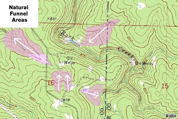 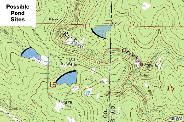
0.6 acre pond / 13' max depth / Bonham, TX
|
|
|
|
|
Joined: Apr 2002
Posts: 1,892
Lunker
|
|
Lunker
Joined: Apr 2002
Posts: 1,892 |
Dang, Jimmy how did you do that? I can read the map but you are a pro. You brought it down on the stupid level so I don't have to read it.
BTW, the oil wells are pretty meaningless in this instance. Unless, of course, you want to put a pond over them. If not currently operating, they will or should be plugged.
|
|
|
|
|
Joined: Mar 2005
Posts: 120
Lunker
|
|
Lunker
Joined: Mar 2005
Posts: 120 |
Just a quick little exercie in Photoshop. As a graphic artist, I come in handy, but only on rare occassions! :p
0.6 acre pond / 13' max depth / Bonham, TX
|
|
|
|
|
Joined: Jun 2005
Posts: 86
Member
|
|
OP
Member
Joined: Jun 2005
Posts: 86 |
Russ that makes total sense from your 1st post, thanks. I can see what you're talking about now.
Theo you make valid points. I guess I should have said I would MAKE an arm from the original creek. This way the water still goes where it has forever, and my neighbor is not "losing" anything. Speaking of, his property is more off to the left of this one, and I don't believe the creek even runs on his lot, so I think I'll be okay.
With the lot being heavily wooded right now, I know I should go walk it, but it's WOODED. I am sure the local NRCS guy I talked to, is use to walking through this type stuff though. (the county he covers is mostly woods and scattered houses.)
Jimmy thanks for visualizing it for me. I am very good with photoshop btw guys if you ever need something done, I just couldn't 'see' how the topo made ponds, but after you Jimmy coloring the watering holes, makes sense and I 'see' it.
What specifically should I be looking for in future lots if the NRCS guy says it's to steep, or to much sand, or adding an arm still won't help, or.....etc? Should I be looking for flat non treed land? (i.e. pastures) I have been told (doesn't mean it's the right information though) that flat land is not that good unless you have enough watershed, but to me flat land would be better like making a pool for example...so I have been looking at 'hilly' land.
My head hurts.
Thanks guys.
|
|
|
|
|
Joined: Jun 2005
Posts: 86
Member
|
|
OP
Member
Joined: Jun 2005
Posts: 86 |
Oh and someone mentioned get an aerial photo, I have one, but it didn't zoom to to much, and didn't help me much since everything around the lot is woods. Hence why I downloaded the topo version. (I printed the aerial for the wife to see)
I do know one absolute fact though about this area....it WILL hold water. There is a lake VERY close to this property, and many many ponds in this area, and even some on the way to the lot.
I will go get an aerial right now, and post it too on this thread.. The lake will be obvious and up to the north in the aerial photo. (should be anyways)
|
|
|
|
|
Joined: Jun 2005
Posts: 86
Member
|
|
OP
Member
Joined: Jun 2005
Posts: 86 |
Here is the aerial. N. and to the Right. is the lake. If I could post a huge aerial I would and it would show a lot of ponds/holding waters etc.  You can see other little bodies though.
|
|
|
|
|
Joined: Mar 2005
Posts: 120
Lunker
|
|
Lunker
Joined: Mar 2005
Posts: 120 |
BD, In response to your comment, What specifically should I be looking for in future lots if the NRCS guy says it's to steep, or to much sand, or adding an arm still won't help, or.....etc? Should I be looking for flat non treed land? The 2 most important things are the soil types and the watershed. Provided you have a soil that will retain water and you have good drainage into your pond, there should be no problem. Thirdly, you want to move as little dirt as possible. If you can find an area on a piece of land that has a nice "U" shape, you can connect the 2 tops of the "U" with a dam and build a lake without much cash. If you have to build a long expansive dam to connect something more in the shape of a smiley face, then it gets expensive. Here's a better illustration to explain the idea: 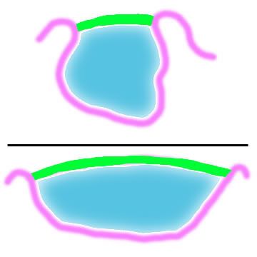
0.6 acre pond / 13' max depth / Bonham, TX
|
|
|
|
|
Joined: May 2004
Posts: 13,985 Likes: 281
Moderator Lunker
|
|
Moderator Lunker
Joined: May 2004
Posts: 13,985 Likes: 281 |
Russ and Jimmy:
You are kind to give me any credit at all - you guys are like topo pros!
"Live like you'll die tomorrow, but manage your grass like you'll live forever." -S. M. Stirling
|
|
|
|
|
Joined: Apr 2002
Posts: 1,011
Lunker
|
|
Lunker
Joined: Apr 2002
Posts: 1,011 |
Thanks Theo but I must confess. I'm just trying to stack the deck in my favor so when I hit you up for pasture land managment advice, I'll have some cards to play.  BD, let me take a brief minute and add to my comment about aerial photos. When aerial photos are taken, there is usually an overlap from one photo to the next. When adjacent photos are viewed using a stereoscope, it creates a 3-D image. Its like using 3-D goggles to view a movie. My first exposure to this occured in college. They gave us photos of a crater. When aligned just right it appeared as if you were on the edge of the crater and one step forward would be your last. Its an image I will never forget. The best thing I could equate that to now would be those I-MAX movies that show you flying over mountain tops and then with out warning, you come to a cliff....  Russ
|
|
|
|
|
Joined: May 2004
Posts: 13,985 Likes: 281
Moderator Lunker
|
|
Moderator Lunker
Joined: May 2004
Posts: 13,985 Likes: 281 |
when I hit you up for pasture land managment advice Ask and ye shall receive - all my mistakes are yours to learn from. You have to learn to love the "smell of money" on your own.
"Live like you'll die tomorrow, but manage your grass like you'll live forever." -S. M. Stirling
|
|
|
|
|
Joined: Jun 2005
Posts: 86
Member
|
|
OP
Member
Joined: Jun 2005
Posts: 86 |
|
|
|
Moderated by Bill Cody, Bruce Condello, catmandoo, Chris Steelman, Dave Davidson1, esshup, ewest, FireIsHot, Omaha, Sunil, teehjaeh57
My First
by H20fwler - 05/06/24 04:29 AM
|
|
|
|
|
|
|
|
|
|
|
|
|
|
|
|
|
|
|
|
|
|
|
|
|
|


