...I look forward to an aerial shot about next Fall.
Me too, Theo....me too.
Looks like a meteorite hit.
would'a been more cost effective
looks like at time of pic, there is water in the pond basin (as the really light brown in deepest areas)?
Yep, it had just started to back up; maybe 4 feet deep in the wide/flat basin afronting the dam. (for a lack of better description) the puddle is shaped like a morel mushroom; the bottom of the stem in the SE and the top of the cap in the NW.
hopefully you get along with that one neighbor to the north.
We actively reached out to all our bordering neighbors. Kinda funny, as we mentioned the names of the other neighbors to each that we were actively visiting, they would usually respond with "sorry, who's that?". Anyway, based on our best job of diplomacy, I feel much better than worse on the results.
also, assuming north is straight up, what is the clearing on east side of property.....looks like soil is exposed there or rock outcrop
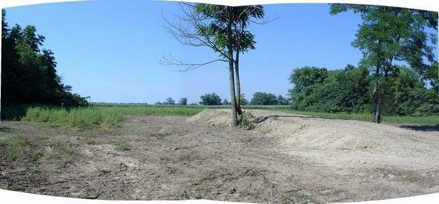
This is an area of 1.75 ac that is a meadow. It had a short hump of dirt with a few ratty trees in it. When the dozer was on site, we had him "pretty up the hump" to create a pad for building a gazebo viewing platform. The plan is to plant a shelterbelt of conifers across the north border (yes, north is up), closing off this meadow with trees at all four sides (there is a thin tree line along the east edge, beneath the yellow property line I inserted). Then, the entire area is gonna get loaded with native grasses and wildflowers. We want this to be a special "destination zone" to balance off the timber.
-
...the view of the meadow, standing south of the small "building pad hump", and looking north. The north end of the treeline along the east edge can be seen right of frame. We will begin the shelterbelt at that point and stretch it west (to the left), effectively closing off this area with trees (someday).