|
Forums36
Topics42,115
Posts571,695
Members19,116
| |
Most Online45,564
Yesterday at 03:05 AM
|
|
|
0 members (),
7,892
guests, and
154
robots. |
|
Key:
Admin,
Global Mod,
Mod
|
|
|
|
Joined: Jul 2007
Posts: 11
Lunker
|
|
Lunker
Joined: Jul 2007
Posts: 11 |
How do I determine how many acres of land that my watershed comes from?
|
|
|
|
|
Joined: Feb 2006
Posts: 1,960 Likes: 20
Moderator Lunker
|
|
Moderator Lunker
Joined: Feb 2006
Posts: 1,960 Likes: 20 |
Last edited by Chris Steelman; 02/07/08 07:32 PM.
|
|
|
|
|
Joined: Jul 2007
Posts: 11
Lunker
|
|
Lunker
Joined: Jul 2007
Posts: 11 |
thanks I will check that out...
Also my pond site has 3 or 4 springs flowing through the area...
How do I calculate the amount of water from the springs?
I'm pretty sure I will have too much water as the springs never run dry so I will need to have some sort of spillway pipe but I need to know how big.
|
|
|
|
|
Joined: Feb 2006
Posts: 1,960 Likes: 20
Moderator Lunker
|
|
Moderator Lunker
Joined: Feb 2006
Posts: 1,960 Likes: 20 |
On the spings take a width and average depth measurement. Then get a speed measurement by placing an object in the water and seeing how far it moves in 1 second. In my Fisheries Techniques class they said that you can use an orange. That will give you how many cubic feet per second that is coming out of the spring. Use this Pipe flow calculator. It will help you determine the flow rate on different size pipes.
|
|
|
|
|
Joined: Jul 2007
Posts: 11
Lunker
|
|
Lunker
Joined: Jul 2007
Posts: 11 |
Thanks again for the info I'll give the orange trick a try.
What do I measure with the google planimeter? I know the amount of acres surrounding my land but obviously I don't get watershed from all of it right?
My pond site is a low spot with a high watershed and its right at the water level. I've done a couple of test holes about 5 ft deep and they filled right up and have not went down. The property behind me is all higher ground then mine and that is 400 acres.
Any help figuring out how to calculate the watershed acres would greatly be appreciated
|
|
|
|
|
Joined: Feb 2006
Posts: 1,960 Likes: 20
Moderator Lunker
|
|
Moderator Lunker
Joined: Feb 2006
Posts: 1,960 Likes: 20 |
Here is a picture of my property and the watershed outlined. 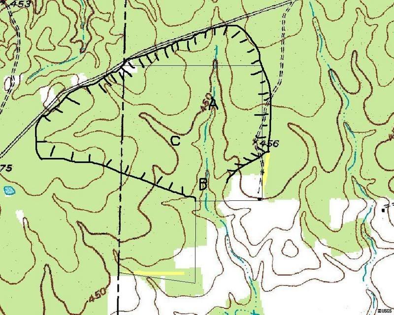 On a topo map the small end of the "V" points upstream. First place a point where the dam will be, then place more points all the way around. For example, on my picture if you go right from point C you will be heading uphill.
|
|
|
|
|
Joined: Apr 2006
Posts: 3,261
Ambassador Lunker
|
|
Ambassador Lunker
Joined: Apr 2006
Posts: 3,261 |
aaron, if you can post a topo of yer pond site and surrounding area, folks here can help you. you need to be able to read the topographic contour lines (hills, valleys, divides) yer watershed will be the entire area sloping towards yer pondsite.
if yer springs are relatively small, a quick and dirty estimate of flow volume can be obtained w/ a 5-gallon bucket....funnel the spring water to a deep spot (maybe have to dig a little) stick the bucket in and time how fast it fills..convert to gallons per minute.
GSF are people too!  
|
|
|
|
|
Joined: Feb 2007
Posts: 121
Lunker
|
|
Lunker
Joined: Feb 2007
Posts: 121 |
you can use google planimeter it will give you the size of teh area you out line
0.22 acre dam pond LMB, BG, and CC
|
|
|
|
|
Joined: Jun 2005
Posts: 2,365
Lunker
|
|
Lunker
Joined: Jun 2005
Posts: 2,365 |
A good trick to measure flow volume is with a piece of bare copper wire or soft baling wire.
Take the wire and bend it to fit the bottom of the stream, following most of the contours except definite holes. Once across, then run the wire back across on the surface of the water. Maybe a better description would be to "wrap the wire around the water". Once that's done, you can cut the wire, and make a square or rectangle out of it, and multiply the length x width. Now you can use the orange trick to easily calculate the flow volume.
A big part of determining your watershed is observation, because maps don't tell the whole story. If you look around after a rain, you can see which land is draining in which direction, and get a rough idea. It's usually a very rough calculation no matter how you do it.
|
|
|
|
|
Joined: Jul 2007
Posts: 11
Lunker
|
|
Lunker
Joined: Jul 2007
Posts: 11 |
Thanks for all the info all...I would have measured the springs already but a cold front came through and it has been 20 blow zero (wind chill) for the last few days.
When I used the google planimeter I couldnt figure out exactly where my pond site is...I new I was close but obviously I need exact right? Should I order a topo for my property and then find it with gps?
|
|
|
|
|
Joined: Apr 2002
Posts: 181
Lunker
|
|
Lunker
Joined: Apr 2002
Posts: 181 |
Bobad, I am not sure that wire bending trick is very accurate.
If the stream were broad but very shallow you would overestimate
the cross sectional area a lot if you deformed the wire into a square or a squarish rectangle. For example, take a skinny rectangle (1/2 ft x 5 1/2 ft) with a circumference of 12 ft and an area of 2 3/4 sq ft. You can deform this 12 ft "wire" loop into a 2ft x 4ft rectangle with an area of 8 sq ft. The skinnier the rectangle, the smaller the area, given the same circumference.
Layton Runkle
|
|
|
|
|
Joined: Mar 2008
Posts: 4
Fingerling
|
|
Fingerling
Joined: Mar 2008
Posts: 4 |
LRunkle's right, the most accurate way to do it is to take a rag tape, stretch it tight and level across your creek and use a survey rod or yard stick and take a depth at each increment, usually 1'. Figure out how high your tape is above the average water level and subtract it from each of your depth readings.
You can then plot it in cad, or on graph paper to be highly accurate. Even easier is to just add all the depths and divide by the count and multiply by the width of the creek to get an average end area of that crossing.
Erich
|
|
|
Moderated by Bill Cody, Bruce Condello, catmandoo, Chris Steelman, Dave Davidson1, esshup, ewest, FireIsHot, Omaha, Sunil, teehjaeh57 |
|







