|
Forums36
Topics40,991
Posts558,286
Members18,517
| |
Most Online3,612
Jan 10th, 2023
|
|
|
15 members (ewest, Fishingadventure, FishinRod, RAH, Don Kennedy, rkleman, Sunil, BarkyDoos, Augie, phinfan, Shorthose, Boondoggle, Brian from Texas, Theo Gallus, Ibanez540r),
1,057
guests, and
295
robots. |
|
Key:
Admin,
Global Mod,
Mod
|
|
|
|
Joined: Jul 2009
Posts: 3,505 Likes: 3
Ambassador Field Correspondent Hall of Fame  Lunker
|

Ambassador Field Correspondent Hall of Fame Lunker
Joined: Jul 2009
Posts: 3,505 Likes: 3 |
From the orientation of the picture, I have to go with left to right for the creek thingie. I have another theory on your quarry itself, that being that the water, independent of wind influence, would flow from the narrow end towards the broad end.
|
|
|
|
|
Joined: Aug 2004
Posts: 8,854 Likes: 1
Moderator Ambassador Field Correspondent Lunker
|
OP
Moderator Ambassador Field Correspondent Lunker
Joined: Aug 2004
Posts: 8,854 Likes: 1 |
I went down to the creek that's on the north side of the quarry last week when we were having a minor snow meltoff, and the water was indeed running from East to West, or right to left.
Question #3. Where's the dam?
Holding a redear sunfish is like running with scissors.
|
|
|
|
|
Joined: Aug 2004
Posts: 8,854 Likes: 1
Moderator Ambassador Field Correspondent Lunker
|
OP
Moderator Ambassador Field Correspondent Lunker
Joined: Aug 2004
Posts: 8,854 Likes: 1 |
....five points for first correct answer. 2 points for every additional correct answer.
Holding a redear sunfish is like running with scissors.
|
|
|
|
|
Joined: Jul 2009
Posts: 3,505 Likes: 3
Ambassador Field Correspondent Hall of Fame Lunker
|
Ambassador Field Correspondent Hall of Fame Lunker
Joined: Jul 2009
Posts: 3,505 Likes: 3 |
I went down to the creek that's on the north side of the quarry last week when we were having a minor snow meltoff, and the water was indeed running from East to West, or right to left.
Question #3. Where's the dam? I may be off base here, but I'm going with the dam being the wide "end" of the lake, or maybe more accurately described at the top of the left side of the "U" shape (top left as we're viewing it in the pics). I'm saying that based on the evident underwater slope visible in the pics, suggesting to me anyway that it's where the dam materials were piled up and sloped into the water. Plus, with you confirming the water runs in that direction, that's my basis for guessing this way!
|
|
|
|
|
Joined: Apr 2006
Posts: 3,261
Ambassador Lunker
|
|
Ambassador Lunker
Joined: Apr 2006
Posts: 3,261 |
i agree todd if we're talkin the same place. here's my take...most of the lake is filled pit. there is a small (primary) dam on the left (west) with a spillway feature. but also, it appears the quarry company bermed the north east side....its not the main dam but appears bermed to build the road, and to prevent water from moving north towards lower elevations. 
GSF are people too!  
|
|
|
|
|
Joined: Jul 2009
Posts: 3,505 Likes: 3
Ambassador Field Correspondent Hall of Fame Lunker
|
Ambassador Field Correspondent Hall of Fame Lunker
Joined: Jul 2009
Posts: 3,505 Likes: 3 |
Yep, DIED, we are talking in the same area, although I'm probably looking a little more up towards that somewhat defined corner than you are after looking at your picture again. I kind of thought about the narrow end for a minute, but it seemed less likely given the overall shape and from my uneducated guesses about the various water features. I had never considered that "creek thingie" as Bruce described it to be a spillway, but that's an interesting supposition you make. I like it! Too bad I'm already committed to saying it's an inflowing stream (from one of my earlier answers) or I might just have to join you on that !
Last edited by Todd3138; 02/10/10 01:06 PM. Reason: clarifying the spot I'm talking about with DIED
|
|
|
|
|
Joined: Jul 2008
Posts: 697
Hall of Fame Lunker
|
Hall of Fame Lunker
Joined: Jul 2008
Posts: 697 |
My guess is The dam is where I made the yellow gob east of the road. 
"I think I have a nibble" Homer Simpson 34ac natural lake  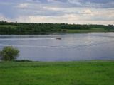
|
|
|
|
|
Joined: Aug 2004
Posts: 8,854 Likes: 1
Moderator Ambassador Field Correspondent Lunker
|
OP
Moderator Ambassador Field Correspondent Lunker
Joined: Aug 2004
Posts: 8,854 Likes: 1 |
I went down to the creek that's on the north side of the quarry last week when we were having a minor snow meltoff, and the water was indeed running from East to West, or right to left.
Question #3. Where's the dam? I may be off base here, but I'm going with the dam being the wide "end" of the lake, or maybe more accurately described at the top of the left side of the "U" shape (top left as we're viewing it in the pics). I'm saying that based on the evident underwater slope visible in the pics, suggesting to me anyway that it's where the dam materials were piled up and sloped into the water. Plus, with you confirming the water runs in that direction, that's my basis for guessing this way! Close...but gets extra credit for nice effort.
Holding a redear sunfish is like running with scissors.
|
|
|
|
|
Joined: Aug 2004
Posts: 8,854 Likes: 1
Moderator Ambassador Field Correspondent Lunker
|
OP
Moderator Ambassador Field Correspondent Lunker
Joined: Aug 2004
Posts: 8,854 Likes: 1 |
i agree todd if we're talkin the same place. here's my take...most of the lake is filled pit. there is a small (primary) dam on the left (west) with a spillway feature. but also, it appears the quarry company bermed the north east side....its not the main dam but appears bermed to build the road, and to prevent water from moving north towards lower elevations. I meant for this to be a trick question, but it didn't fool DIED. Yes there are two dams, and they are both outlined precisely in this answer.
Holding a redear sunfish is like running with scissors.
|
|
|
|
|
Joined: Jul 2008
Posts: 697
Hall of Fame Lunker
|
Hall of Fame Lunker
Joined: Jul 2008
Posts: 697 |
DAM IT!!!! I thought it was going to be trickier then that.
"I think I have a nibble" Homer Simpson 34ac natural lake
|
|
|
|
|
Joined: Aug 2004
Posts: 8,854 Likes: 1
Moderator Ambassador Field Correspondent Lunker
|
OP
Moderator Ambassador Field Correspondent Lunker
Joined: Aug 2004
Posts: 8,854 Likes: 1 |
Current standings.
DIED = 12
Todd3138 = 5 1/2
ewest = 4 1/2
Greg Grimes = 4
Dwight = 2.1
Burgermeister = 2
CJBS = 2
DaveDavidson = 2
Omaha = 2
Youngblood = 1
essup = 1
blair5002 = 1
JHAP = 7/8
Yolkie = 1/2
Holding a redear sunfish is like running with scissors.
|
|
|
|
|
Joined: Aug 2004
Posts: 8,854 Likes: 1
Moderator Ambassador Field Correspondent Lunker
|
OP
Moderator Ambassador Field Correspondent Lunker
Joined: Aug 2004
Posts: 8,854 Likes: 1 |
Question #4:
Tell me why there's a clue on this summertime map as to where there are currently thin/weak spots in the ice this winter.
3 points for correct answers. 5 points for first correct answer.
Holding a redear sunfish is like running with scissors.
|
|
|
|
|
Joined: Jul 2008
Posts: 697
Hall of Fame Lunker
|
Hall of Fame Lunker
Joined: Jul 2008
Posts: 697 |
I was thinking the pit on the east side of road has blocked the natural water flow and directed it underground to your pond.
"I think I have a nibble" Homer Simpson 34ac natural lake
|
|
|
|
|
Joined: Aug 2004
Posts: 8,854 Likes: 1
Moderator Ambassador Field Correspondent Lunker
|
OP
Moderator Ambassador Field Correspondent Lunker
Joined: Aug 2004
Posts: 8,854 Likes: 1 |
I was thinking the pit on the east side of road has blocked the natural water flow and directed it underground to your pond. I believe you are exactly right. The anecdotal evidence is that the static water level has increased since the natural water flow has been impeded on the east side of the road. The only problem is, that was going to be question #5!  I'll give you a bonus point! 
Holding a redear sunfish is like running with scissors.
|
|
|
|
|
Joined: Jul 2008
Posts: 697
Hall of Fame Lunker
|
Hall of Fame Lunker
Joined: Jul 2008
Posts: 697 |
"I think I have a nibble" Homer Simpson 34ac natural lake
|
|
|
|
|
Joined: Jul 2009
Posts: 3,505 Likes: 3
Ambassador Field Correspondent Hall of Fame Lunker
|
Ambassador Field Correspondent Hall of Fame Lunker
Joined: Jul 2009
Posts: 3,505 Likes: 3 |
Question #4:
Tell me why there's a clue on this summertime map as to where there are currently thin/weak spots in the ice this winter.
3 points for correct answers. 5 points for first correct answer. Alright, I don't know what happened, but I tried posting this once and hit a key accidentally and the unfinished answer disappeared. If it shows up later, I'm pleading to the court for leniency in not considering this as an edited answer and disqualifying it! I am calling two areas where there could be thin ice issues. 1) The narrow end of the lake for two reasons: a) Your observation that surface water flow tends to run from that area towards the wide end. As such, since it's a more constricted area where surface action is more likely be a factor than the wider areas, that may present difficulties for consistent freezing, and b) from the pictures, it looks like that area is more affected by wind action at the surface, another factor making it a little tougher to get a solid freeze compared to areas where the surface is more protected from wind movement. 2) On the wide end, right around the dam area and back towards the dark spot that sits sort of in the middle of the channel. My reasoning, a) That end of the lake will also have some additional wind exposure that will keep the surface a little more agitated, b) the outflow into the dam overflow identified by DIED will have increased water movement and correspondingly thinner ice, and c) here's where I'm going way out on a limb, I think that dark spot in the middle of the channel is an opening to a subsurface "well" within the limestone aquifer and that there is water upwelling there. That water is going to be warmer and I believe it will cause a column of warmer water that will resist freezing, perhaps altogether except on the coldest days. There. I've said it. I'm committed to it. I just hope my novice-ness doesn't come back and bite me in the backside for it!
|
|
|
|
|
Joined: Apr 2006
Posts: 3,261
Ambassador Lunker
|
|
Ambassador Lunker
Joined: Apr 2006
Posts: 3,261 |
no fair, the questions are gettin harder.
i agree todd, sure looks like there could be springs or upwelling groundwater in the deep areas on the western arm.
GSF are people too!
|
|
|
|
|
Joined: Apr 2006
Posts: 3,261
Ambassador Lunker
|
|
Ambassador Lunker
Joined: Apr 2006
Posts: 3,261 |
potential spring loci: 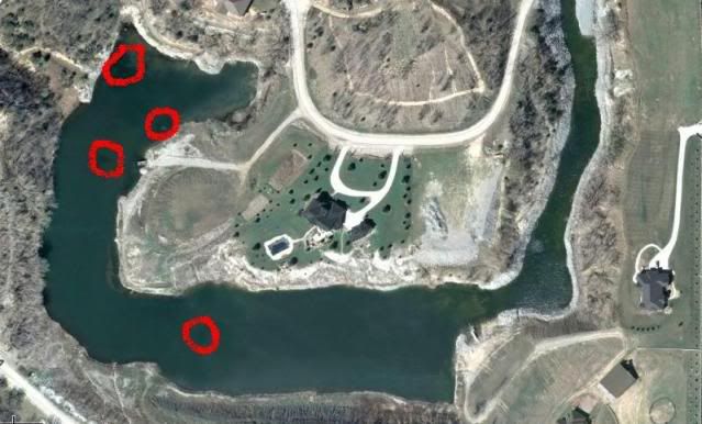
GSF are people too!
|
|
|
|
|
Joined: Apr 2006
Posts: 3,261
Ambassador Lunker
|
|
Ambassador Lunker
Joined: Apr 2006
Posts: 3,261 |
before bruce gets to his next question i have to offer an alternative origin for the pond, for you conspiracy theorists, the quarry company did not create that pit at all, and the mining operations were conducted to exploit rare extra terrestrial metals - the pond's geomorphology cries out for this.....you be the judge.....  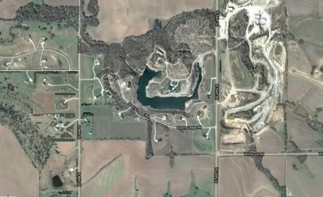 hmmm.....
GSF are people too!
|
|
|
|
|
Joined: Aug 2004
Posts: 8,854 Likes: 1
Moderator Ambassador Field Correspondent Lunker
|
OP
Moderator Ambassador Field Correspondent Lunker
Joined: Aug 2004
Posts: 8,854 Likes: 1 |
before bruce gets to his next question i have to offer an alternative origin for the pond, for you conspiracy theorists, the quarry company did not create that pit at all, and the mining operations were conducted to exploit rare extra terrestrial metals - the pond's geomorphology cries out for this.....you be the judge..... You can tell that DIED is hearing footsteps. He's now going after some of JHAP's humor points.hmmm.....
Last edited by Bruce Condello; 02/11/10 03:20 PM.
Holding a redear sunfish is like running with scissors.
|
|
|
|
|
Joined: Aug 2009
Posts: 150
Lunker
|
|
Lunker
Joined: Aug 2009
Posts: 150 |
Quick Question
Can one of you really smart people show me where I can get a water flood calculation or an archive link that has it? I cannot find it and the ones I located on the internet all deal with programs that I have no clue....The simpler the better....humbling asking...blush blush...
I subscribe!
|
|
|
|
|
Joined: Apr 2006
Posts: 3,261
Ambassador Lunker
|
|
Ambassador Lunker
Joined: Apr 2006
Posts: 3,261 |
from my perspective, its a great question but not a quick question. there are many variables to consider for an accurate calculation including water shed size, channel sizes, statistical analysis of historic precipitation amounts particularly as they relate to selected time periods (i.e. 24-hr event, 48-hr event, etc...), soil types, permeability, infiltration, run-off volume and rates.....most of these variables have to be estimated or calculated on their own then plugged into "master equation" to accurately predict or estimate peak flood conditions and subsequent design of spillways etc...thats why people hire engineers  if ewest or somebody else knows of or can find a link to a simpler approach, i'd love to see it as well. hijack off... p.s. coupe.....start a new thread and re-ask the question, it'l get some attention
Last edited by dave in el dorado ca; 02/11/10 06:48 PM.
GSF are people too!
|
|
|
|
|
Joined: Aug 2009
Posts: 150
Lunker
|
|
Lunker
Joined: Aug 2009
Posts: 150 |
Thanks.
Really had no idea....blush
I subscribe!
|
|
|
|
|
Joined: Mar 2005
Posts: 21,508 Likes: 269
Moderator Hall of Fame 2014 Lunker
|

Moderator Hall of Fame 2014 Lunker
Joined: Mar 2005
Posts: 21,508 Likes: 269 |
The "springs" as DIED notes are really fractured limestone that connects to both the groundwater on site and to the quarry to the east which is impounded by the road and forced through the fracture system to Bruce's pond. I think that gets 2 questions.
Not sure what you mean by "a water flood calculation ". There are several threads on sizing overflow systems and on caculating watershed.
Last edited by ewest; 02/12/10 08:57 AM.
|
|
|
|
|
Joined: Jan 2006
Posts: 16,060 Likes: 278
Moderator Lunker
|
|
Moderator Lunker
Joined: Jan 2006
Posts: 16,060 Likes: 278 |
Actually, the entire area is an aquifer.
It's not about the fish. It's about the pond. Take care of the pond and the fish will be fine. PB subscriber since before it was in color.
Without a sense of urgency, Nothing ever gets done.
Boy, if I say "sic em", you'd better look for something to bite. Sam Shelley Rancher and Farmer Muleshoe Texas 1892-1985 RIP
|
|
|
Moderated by Bill Cody, Bruce Condello, catmandoo, Chris Steelman, Dave Davidson1, esshup, ewest, FireIsHot, Omaha, Sunil, teehjaeh57
|
|
|
|
|
|
|
|
|
|
My First
by H20fwler - 05/06/24 04:29 AM
|
|
|
|
|
|
|
|
|
|
|
|
|
|
|
|


.gif)