|
Forums36
Topics40,947
Posts557,803
Members18,484
| |
Most Online3,612
Jan 10th, 2023
|
|
|
10 members (FishinRod, jludwig, Donatello, DrewSh, shores41, Steve Clubb, Justin W, Joe7328, catscratch, Knobber),
1,004
guests, and
237
robots. |
|
Key:
Admin,
Global Mod,
Mod
|
|
|
|
Joined: Apr 2006
Posts: 3,261
Ambassador Lunker
|

Ambassador Lunker
Joined: Apr 2006
Posts: 3,261 |
ground water and precipitation 
GSF are people too!  
|
|
|
|
|
Joined: Apr 2006
Posts: 3,261
Ambassador Lunker
|
|
Ambassador Lunker
Joined: Apr 2006
Posts: 3,261 |
since i cant edit posts, i have to correct for prior fat finger typos......sp: fossiliferous
is the limestone fossiliferous?
GSF are people too!
|
|
|
|
|
Joined: Mar 2005
Posts: 21,490 Likes: 265
Moderator Hall of Fame 2014  Lunker
|
Moderator Hall of Fame 2014 Lunker
Joined: Mar 2005
Posts: 21,490 Likes: 265 |
Is it a limestone quarry or gravel - what was mined?
|
|
|
|
|
Joined: Apr 2006
Posts: 3,261
Ambassador Lunker
|
|
Ambassador Lunker
Joined: Apr 2006
Posts: 3,261 |
there was a pic bruce posted on page 2 of the home run thread that looks like highly fractured although relatively undeformed limestone: http://www.pondboss.com/forums/ubbthreads.php?ubb=showflat&Number=202808&fpart=2i never congratulated you BTW bruce.....as such congrats  i'm just a bit jealous in el dorado
GSF are people too!
|
|
|
|
|
Joined: Mar 2005
Posts: 21,490 Likes: 265
Moderator Hall of Fame 2014 Lunker
|
Moderator Hall of Fame 2014 Lunker
Joined: Mar 2005
Posts: 21,490 Likes: 265 |
So DIED you were mining the other thread for data to give you an advantage here?  Just like a Geologist. Good thought- I should have thought of that.  -   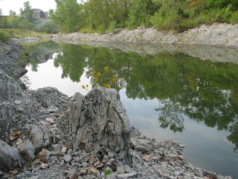
|
|
|
|
|
Joined: Apr 2006
Posts: 3,261
Ambassador Lunker
|
|
Ambassador Lunker
Joined: Apr 2006
Posts: 3,261 |
i'm not sure there is enough elevation in the region for this thought, its hard to tell on sat.image (w/out contour lines) but it appears there could be some form of terraced drain system between the active pit east of the hwy, to bruces filled pit west of the hwy both connected to the e-w running creek north of both properties. when they quit digging on the west side, they dammed it up so it could fill w/ groundwater and precipitation. also explains why they dont have to pump out the active quarry. thoughts??
GSF are people too!
|
|
|
|
|
Joined: Dec 2004
Posts: 5,713 Likes: 35
Administrator Lunker
|
|
Administrator Lunker
Joined: Dec 2004
Posts: 5,713 Likes: 35 |
|
|
|
|
|
Joined: Mar 2005
Posts: 21,490 Likes: 265
Moderator Hall of Fame 2014 Lunker
|
Moderator Hall of Fame 2014 Lunker
Joined: Mar 2005
Posts: 21,490 Likes: 265 |
Yes and could also be a fractured drain from the east pit to the west so Bruce gets the water from both GW and rain/runoff attributable to both irrespective of surface elevation.
|
|
|
|
|
Joined: Aug 2004
Posts: 8,854 Likes: 1
Moderator Ambassador Field Correspondent Lunker
|
OP
Moderator Ambassador Field Correspondent Lunker
Joined: Aug 2004
Posts: 8,854 Likes: 1 |
Is it a limestone quarry or gravel - what was mined? It was my understanding the the mined limestone was crushed to make white rock for our country roads.
Holding a redear sunfish is like running with scissors.
|
|
|
|
|
Joined: Aug 2004
Posts: 8,854 Likes: 1
Moderator Ambassador Field Correspondent Lunker
|
OP
Moderator Ambassador Field Correspondent Lunker
Joined: Aug 2004
Posts: 8,854 Likes: 1 |
Yes and could also be a fractured drain from the east pit to the west so Bruce gets the water from both GW and rain/runoff attributable to both irrespective of surface elevation. There's a double score.
Holding a redear sunfish is like running with scissors.
|
|
|
|
|
Joined: Aug 2004
Posts: 8,854 Likes: 1
Moderator Ambassador Field Correspondent Lunker
|
OP
Moderator Ambassador Field Correspondent Lunker
Joined: Aug 2004
Posts: 8,854 Likes: 1 |
I was not going to play but now knowing points go toward prizes and lodging. I say due to clairty/color the major water source is GROUNDWATER via aquifer and not as much surface runoff as others seem to think. Double points.
Holding a redear sunfish is like running with scissors.
|
|
|
|
|
Joined: Aug 2004
Posts: 8,854 Likes: 1
Moderator Ambassador Field Correspondent Lunker
|
OP
Moderator Ambassador Field Correspondent Lunker
Joined: Aug 2004
Posts: 8,854 Likes: 1 |
i'm not sure there is enough elevation in the region for this thought, its hard to tell on sat.image (w/out contour lines) but it appears there could be some form of terraced drain system between the active pit east of the hwy, to bruces filled pit west of the hwy both connected to the e-w running creek north of both properties. when they quit digging on the west side, they dammed it up so it could fill w/ groundwater and precipitation. also explains why they dont have to pump out the active quarry. thoughts?? Triple points. Geoligist consulted believes that the east side pit, because of the "recontouring" is trapping groundwater and sending it west to the quarry pit.
Last edited by Bruce Condello; 02/05/10 05:31 PM.
Holding a redear sunfish is like running with scissors.
|
|
|
|
|
Joined: Aug 2004
Posts: 8,854 Likes: 1
Moderator Ambassador Field Correspondent Lunker
|
OP
Moderator Ambassador Field Correspondent Lunker
Joined: Aug 2004
Posts: 8,854 Likes: 1 |
Question #2:
What direction does the primary watershed run and why?
Single point available.
Holding a redear sunfish is like running with scissors.
|
|
|
|
|
Joined: Aug 2004
Posts: 8,854 Likes: 1
Moderator Ambassador Field Correspondent Lunker
|
OP
Moderator Ambassador Field Correspondent Lunker
Joined: Aug 2004
Posts: 8,854 Likes: 1 |
since i cant edit posts, i have to correct for prior fat finger typos......sp: fossiliferous
is the limestone fossiliferous? I haven't run across any fossils, but I haven't really looked very much. Some of the limestone is very solid, while in many other areas it's very soft. How would I look?
Last edited by Bruce Condello; 02/05/10 06:45 PM.
Holding a redear sunfish is like running with scissors.
|
|
|
|
|
Joined: Feb 2006
Posts: 1,948 Likes: 9
Moderator Lunker
|
|
Moderator Lunker
Joined: Feb 2006
Posts: 1,948 Likes: 9 |
East to West
The other ponds in the area look like the dam is on the west or northwest side.
The draw DD mentioned earlier looks like it could be the spillway instead of the infow.
|
|
|
|
|
Joined: Apr 2006
Posts: 3,261
Ambassador Lunker
|
|
Ambassador Lunker
Joined: Apr 2006
Posts: 3,261 |
i agree w/ you chris but for a different reason. if you look at pic 1 (the far away shot) you can easily discern the dendritic pattern of the drainage. water flows from the outermost branches towards the main trunk......east to west.... who's line is it anyway? this could be the game where the points dont matter, kind of like the first 47 minutes of an NBA game
GSF are people too!
|
|
|
|
|
Joined: Aug 2004
Posts: 8,854 Likes: 1
Moderator Ambassador Field Correspondent Lunker
|
OP
Moderator Ambassador Field Correspondent Lunker
Joined: Aug 2004
Posts: 8,854 Likes: 1 |
"Dendritic" I love it! :-) There's a bonus point for use of the word dendritic. Examples of dendritic patterns...  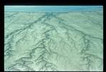 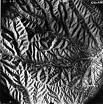 
Last edited by Bruce Condello; 02/05/10 06:42 PM. Reason: added dendritic patterns
Holding a redear sunfish is like running with scissors.
|
|
|
|
|
Joined: Aug 2004
Posts: 8,854 Likes: 1
Moderator Ambassador Field Correspondent Lunker
|
OP
Moderator Ambassador Field Correspondent Lunker
Joined: Aug 2004
Posts: 8,854 Likes: 1 |
So "people spitting in quarry" won't count. I was going to go with "other bodily functions that produce liquids" when I remembered that we're talking Nebraska, not Texas. LOL 1/2 point for being funny.
Holding a redear sunfish is like running with scissors.
|
|
|
|
|
Joined: Jan 2009
Posts: 28,512 Likes: 831
Moderator Ambassador Field Correspondent Lunker
|
Moderator Ambassador Field Correspondent Lunker
Joined: Jan 2009
Posts: 28,512 Likes: 831 |
I figure I'm so far behind that I won't catch up, besides I will be pretty busy in the next 2 days.
So, I have 2 questions for Bruce:
1) How many other houses are/could be in the future on this BOW?
2) It looks like there was a road or berm separating the East BOW from the West BOW, but that isn't there in the most recent satellite view. How deep did they dig that area when the soil/rocks were removed?
|
|
|
|
|
Joined: Aug 2004
Posts: 8,854 Likes: 1
Moderator Ambassador Field Correspondent Lunker
|
OP
Moderator Ambassador Field Correspondent Lunker
Joined: Aug 2004
Posts: 8,854 Likes: 1 |
I figure I'm so far behind that I won't catch up, besides I will be pretty busy in the next 2 days.
So, I have 2 questions for Bruce:
1) How many other houses are/could be in the future on this BOW?
2) It looks like there was a road or berm separating the East BOW from the West BOW, but that isn't there in the most recent satellite view. How deep did they dig that area when the soil/rocks were removed? NEVER give up. Don't EVER give up! There will be questions worth way more points later on. And there will be questions that are only up until the first person answers. So there will be TONS of opportunities to catch up! Answer to you first question: Only two more houses can ever be built on the lake. Mine will be one of them, and the other does not seem to be anywhere in the immediate future. Answer to the second question: The owner of the final lakeside lot dammed the eastern north/south arm so that he could personally excavate it just a couple of years ago. After excavation was complete, he removed his makeshift dam and the East arm was born! I was out on that arm on the ice last Sunday, and the entire arm immediately drops off to 7 feet of water, but doesn't seem to exceed 9 feet anywhere. In my book it's perfect, because it will be very resistant to rooted vegetation growth due to steep sides, but shallow enough to never entirely stratify. It should all be productive water.
Last edited by Bruce Condello; 02/05/10 07:18 PM.
Holding a redear sunfish is like running with scissors.
|
|
|
|
|
Joined: Aug 2004
Posts: 8,854 Likes: 1
Moderator Ambassador Field Correspondent Lunker
|
OP
Moderator Ambassador Field Correspondent Lunker
Joined: Aug 2004
Posts: 8,854 Likes: 1 |
Acceptable answers for first question were "surface water" and "groundwater". Points so far. By the way, don't bother complaining about the points. I can't add anyway. DIED--7 ewest--4 Grimes--4 Dwight--2.1 BM--2 CJBS--2 DD1--1 Todd3138--2 Omaha--2 Youngblood--1 JHAP--3/4 Yolkie--1/2 There will be prizes for 1st, 2nd and randomly picked participant. If you are randomly chosen I will donate $25 to Jesse West Foundation in your name.
Holding a redear sunfish is like running with scissors.
|
|
|
|
|
Joined: Jan 2009
Posts: 28,512 Likes: 831
Moderator Ambassador Field Correspondent Lunker
|
Moderator Ambassador Field Correspondent Lunker
Joined: Jan 2009
Posts: 28,512 Likes: 831 |
Question #2:
What direction does the primary watershed run and why?
Single point available. West to East. Pond location is East of the Contenental Divide, and West of the Mississippi River. Now, if you want the secondary watershed direction, that's a horse of a different color.......
|
|
|
|
|
Joined: May 2002
Posts: 3,973
Ambassador
Field Correspondent Lunker
|
|
Ambassador
Field Correspondent Lunker
Joined: May 2002
Posts: 3,973 |
Oh I got this one in the bag, anyone can see this is a typical oxbow lake. It was formed by the river that miraclous disappeared so it now has no watershed at all, nice try Bruce.
ok I will go north to south just to be different as long as I do not have to show my math.
|
|
|
|
|
Joined: Jan 2009
Posts: 28,512 Likes: 831
Moderator Ambassador Field Correspondent Lunker
|
Moderator Ambassador Field Correspondent Lunker
Joined: Jan 2009
Posts: 28,512 Likes: 831 |
After further reflection, I need to clarify my answer. The primary watershed is the Mississippi Watershed, which runs West to East until it actually enters the Mississippi River, then it runs from North to South.
|
|
|
|
|
Joined: Aug 2004
Posts: 8,854 Likes: 1
Moderator Ambassador Field Correspondent Lunker
|
OP
Moderator Ambassador Field Correspondent Lunker
Joined: Aug 2004
Posts: 8,854 Likes: 1 |
Wouldn't that make the "pictured watershed" actually the tertiary or quaternary watershed?
Holding a redear sunfish is like running with scissors.
|
|
|
Moderated by Bill Cody, Bruce Condello, catmandoo, Chris Steelman, Dave Davidson1, esshup, ewest, FireIsHot, Omaha, Sunil, teehjaeh57 |
|


.gif)