|
Forums36
Topics40,944
Posts557,789
Members18,483
| |
Most Online3,612
Jan 10th, 2023
|
|
|
8 members (FireIsHot, canyoncreek, Augie, Bigtrh24, Shorthose, Theo Gallus, esshup, JasonInOhio),
828
guests, and
296
robots. |
|
Key:
Admin,
Global Mod,
Mod
|
|
|
|
Joined: Jan 2008
Posts: 471
Lunker
|
OP

Lunker
Joined: Jan 2008
Posts: 471 |
I was wanting to get a Aerial map of my pond. I want a big one to put on the wall. Does anyone know where I should look to find something like that?
|
|
|
|
|
Joined: Apr 2002
Posts: 1,488 Likes: 2
Lunker
|
|
Lunker
Joined: Apr 2002
Posts: 1,488 Likes: 2 |
Google Earth PRO can generate an image of 4800x3175, from which a decently large poster can be produced by a print-shop. The currently displayed satellite images for Georgia were made in either '08 or '09. Shoot me the coordinates of your pond if you're interested in checking it out.
|
|
|
|
|
Joined: Jan 2008
Posts: 471
Lunker
|
|
OP
Lunker
Joined: Jan 2008
Posts: 471 |
Kelly heres the coordinates.
Latitude: N 33.53178
N 33� 31' 54.4"
Longitude: W 82.39171
W 82� 23' 30.2"
Last edited by jsand13; 01/16/11 11:35 PM.
|
|
|
|
|
Joined: Apr 2002
Posts: 1,488 Likes: 2
Lunker
|
|
Lunker
Joined: Apr 2002
Posts: 1,488 Likes: 2 |
Found it. Give me a couple of minutes.
|
|
|
|
|
Joined: Apr 2002
Posts: 1,488 Likes: 2
Lunker
|
|
Lunker
Joined: Apr 2002
Posts: 1,488 Likes: 2 |
Had to guess where the shoreline ran due to the tree-canopy, but measures around 8.6 acres. Correct? Image was taken on 6/24/09. Unfortunately, Google's satellite images over rural areas are typically low-resolution. In some of their hi-res images, you can actually see the shadows of people (walking on sidewalks). Here's a downsized image (640x512). I also have it in 3500x2800 format - but it's resolution isn't the greatest. I'll send it to you via email. 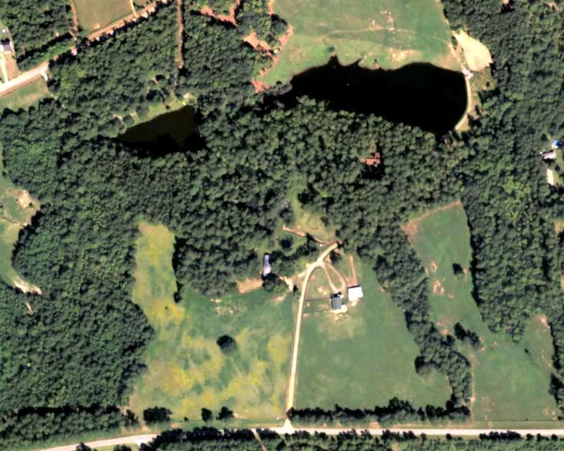
|
|
|
|
|
Joined: Jan 2009
Posts: 28,508 Likes: 829
Moderator Ambassador Field Correspondent  Lunker
|

Moderator Ambassador Field Correspondent Lunker
Joined: Jan 2009
Posts: 28,508 Likes: 829 |
Check into the local airport and ask around. There might be someone that flies out of there that takes aerial photo's if the Google one isn't clear enough or recent enough for you.
|
|
|
|
|
Joined: Apr 2008
Posts: 47
Lunker
|
|
Lunker
Joined: Apr 2008
Posts: 47 |
jsand13, I had aerial photos taken this summer of my land and am having another set taken on 5 Feb to see the difference between summer and winter foliage. I paid around $80 plus $10 for the high-res pics on a disc. He is charging me the same price for February photos. Usually he charges more but because I don't really need them asap, he just passes over my place on his way to other jobs. Appling is about 80 miles as the crow flies from my place and he covers Augusta area as well. If you want, I can pm you with his details and email a couple pics to get a good idea of what you'd be getting. He posts them to his FTP site and provides you a password/user name.
For resolution, you really can't beat google earth. But my area hasn't been updated since early 2007 and I have made a few changes like building a house, timbering about 100 acres of pines, and adding some pasture land. I like seeing the progress and the aerial photos are great for that. If you coordinate well enough, you can even be outside with the family when he passes over for a neat family picture. You'll look like ants but still... Chad
Last edited by edinbowen; 01/17/11 08:57 AM.
|
|
|
|
|
Joined: Jan 2008
Posts: 471
Lunker
|
|
OP
Lunker
Joined: Jan 2008
Posts: 471 |
Thanks Kelly. Is there a way to zoom it in a little more. That upper pond doesnt belong to me. So you got 8.6 acres on both ponds or just the bigger one?
Edinbowen I have a freinf that flies small planes at the local airport but I didnt even think about that. I wonder with would give you a better quality pic. My area was updated last year so everything is pretty accurate on google earth.
|
|
|
|
|
Joined: Apr 2002
Posts: 1,488 Likes: 2
Lunker
|
|
Lunker
Joined: Apr 2002
Posts: 1,488 Likes: 2 |
The lower pond is just shy of 5-acres; but it was hard to determine the south shoreline's edge. You'd likely get a better picture from the pilot if he can take the shot from a northern perspective, and especially if he has a passenger taking the picture instead of himself. 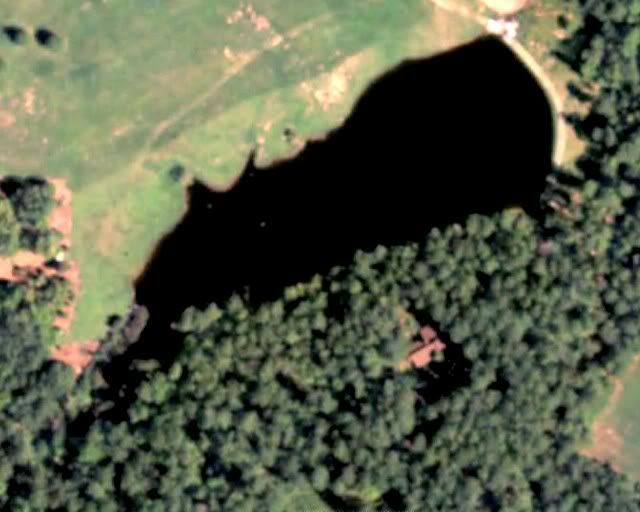
|
|
|
|
|
Joined: Oct 2005
Posts: 6,934 Likes: 2
Ambassador
Field Correspondent Lunker
|
|
Ambassador
Field Correspondent Lunker
Joined: Oct 2005
Posts: 6,934 Likes: 2 |
The mapquest version is a bit clearer, albeit darker. mapquest aerial
|
|
|
|
|
Joined: May 2008
Posts: 376
Lunker
|
|
Lunker
Joined: May 2008
Posts: 376 |
Too bad Bing Maps doesn't have bird's eye angled view for yours. That looks to be the most up to date for mine, well half since they only updated half of mine. I can count branches on trees and see brush piles underwater.
|
|
|
|
|
Joined: Jan 2008
Posts: 471
Lunker
|
|
OP
Lunker
Joined: Jan 2008
Posts: 471 |
The mapquest map isnt the updated one.
Kelly that pic you have up there would work ok. So how do I go about getting a bigger print of it made?
|
|
|
|
|
Joined: Jan 2008
Posts: 471
Lunker
|
|
OP
Lunker
Joined: Jan 2008
Posts: 471 |
I was on some website a while back that had the birds eye view of my place but I cant remember which on it was.
|
|
|
|
|
Joined: Dec 2009
Posts: 6,692
Hall of Fame 2015 Lunker
|
|
Hall of Fame 2015 Lunker
Joined: Dec 2009
Posts: 6,692 |
The mapquest map isnt the updated one.
Kelly that pic you have up there would work ok. So how do I go about getting a bigger print of it made? You could bring it to someone with a color plotter to get a wall size. They could crisp it up a bit with filters and such, but it will still be the same resolution or so as the original. Microsoft, which is now Bing, updated our satellite photos around March of last year. Pretty crummy, as it turns out. Only trees I can see are pines, the rest (oak) only throw shadows. Damn near looks like a wasteland!
|
|
|
|
|
Joined: Apr 2002
Posts: 1,488 Likes: 2
Lunker
|
|
Lunker
Joined: Apr 2002
Posts: 1,488 Likes: 2 |
I'll email the larger file-version (3500x2800) to you. It is cropped for an 8x10 orientation. I can submit the digital image to almost any on-line photo-developer and tell them the print-size (or poster-size) you want and they'll mail it back to you (upon payment, of course).
|
|
|
|
|
Joined: Jan 2008
Posts: 471
Lunker
|
|
OP
Lunker
Joined: Jan 2008
Posts: 471 |
|
|
|
|
|
Joined: May 2002
Posts: 3,973
Ambassador
Field Correspondent Lunker
|
|
Ambassador
Field Correspondent Lunker
Joined: May 2002
Posts: 3,973 |
Jes you can size anything you want at this site ( good for yoru landscape business as well). Easy to use. http://www.acme.com/planimeter/I also asked Steve with the Mapping Network to chime in if he has a moment. We can have them map and print yoru pond for you. They pay for higher resolution imagery. You start blowing up the normal google image and it gets very grainy. Ed, can you post here or email the aerial imagery guy contact info. We get request for that all the time. It is nto Lane Wimberly is it? Thanks
|
|
|
|
|
Joined: Jan 2008
Posts: 471
Lunker
|
|
OP
Lunker
Joined: Jan 2008
Posts: 471 |
Thanks Greg. All I want is just a nice clear poster size pic of my pond. I dont want to spend a bunch of money having a fancy map made with depths and everything on it since its winter and buisiness is slow. Does Steve do somple aerial photos too or just those nice lake maps that are in your electrofishing report?
|
|
|
|
|
Joined: Apr 2008
Posts: 47
Lunker
|
|
Lunker
Joined: Apr 2008
Posts: 47 |
Greg, I use Michael Mullins at Vertical Development. pics@mullinsphoto.net, (478) 973-5769
Chad
|
|
|
|
|
Joined: Jan 2011
Posts: 1
|
|
Joined: Jan 2011
Posts: 1 |
Thanks Greg and Jes. There are a lot of good sources of imagery out there. Some are free and some you can subscribe too. I know for sure we have 2010 1 meter resolution and older 1 foot resolution. We will email a proof. If you can find someone to fly/photo for an inexpensive price we can print that for you too. We have a high quality photo printer and do this for landowners on a daily basis. We also have a r/c helicopter we use to fly properties for real estate that works well for high quality aerial images. http://www.youtube.com/watch?v=DQuN4KwmrcoLet me know if you have any questions! Thanks. Steve
|
|
|
|
|
Joined: Jan 2008
Posts: 471
Lunker
|
|
OP
Lunker
Joined: Jan 2008
Posts: 471 |
Thanks Steve! I got the proof.
|
|
|
|
|
Joined: May 2002
Posts: 3,973
Ambassador
Field Correspondent Lunker
|
|
Ambassador
Field Correspondent Lunker
Joined: May 2002
Posts: 3,973 |
Thanks Ed- Mullins sent email. Thanks Steve for posting info.
|
|
|
|
|
Joined: Apr 2006
Posts: 2,505
Ambassador Field Correspondent Hall of Fame Lunker
|
Ambassador Field Correspondent Hall of Fame Lunker
Joined: Apr 2006
Posts: 2,505 |
I just had steve print off some big aerial maps for a property we are renovating and they were amazing quality. Less than $100 and you can have a very detailed high quality large wall map of your place shipped to you.
We were using the maps for planning purposes and the owner liked em so much he wanted 2 extra to hang on the wall!
|
|
|
Moderated by Bill Cody, Bruce Condello, catmandoo, Chris Steelman, Dave Davidson1, esshup, ewest, FireIsHot, Omaha, Sunil, teehjaeh57 |
|