Pond Boss
My name is Dustin Pratt, I am a proud new member of Pond Boss. I can't wait till my first issue in the mail!

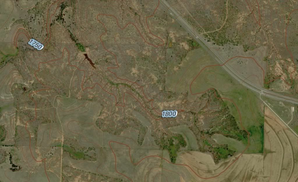
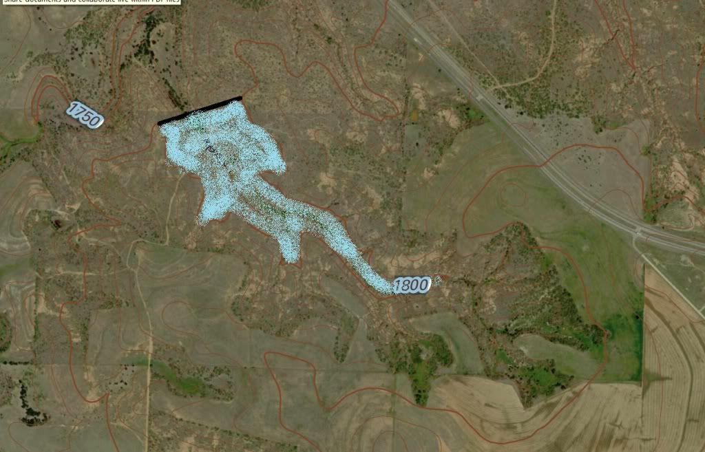
I am actively looking for land close to my home. I have found a 330 acre spread only 5 miles from my home. I think it has AMAZING potential for producing a large pond (20-30 acres)

I have spend the last several weeks reading, measuring, and trying to decide if this is going to work. I don't wont to buy the land unless I have a very good chance of making a large pond.

I have talked to a local dirt man, and he thinks it is a great sight. He is good, but I am probably going to call Otto As he lives like 3.5 hours from me. I also plan to talk to NRCS soon.


Any topo readers out there with some suggestions? will it work?

Current:


After Dam:


The links have a higher resolution picture...

thanks


Dustin

Attached picture old lake with topo.jpg
Attached picture old lake with paint.jpg
Hi Dustin, and welcome to the show my friend!
I agree; it is an amazing topo and could definitely yield on big ol' pond/lake. Based on the topo, though, I see one incredibly tall dam at about 30 - 40 feet at the middle. This would likely require professional engineering, permitting, and annual dam integrity inspections. It would also require an equally incredible amount of dirt movement...$$$
I truly hope you are able to bring this one to fruition, but it will be an immense project. It all comes down to bank account.
Yah,

I was afraid of that... We might have to back off a little and make it not as tall. I am planning on spending a good chunk of change.

I worry about how much land drains into the canyon. I am hopeful it is enough to "fill 'er up"...
If you want to figure out how big your watershed is you can use this website.

www.acme.com/planimeter
chris, outside of the small canyon that I plan to dam up, it flattens out into CRP and then some cotton fields. they still seem to drain into the area.


You can see the exact place by putting these coordinates at this website:
http://itouchmap.com/latlong.html

Lat: 34.48483032577069
Long: -100.3536057472229


maybe you can see the fields I am talking about... should I include these fields?
from a quickie review of your original topo, it appeared to have plenty of run off from the surrounding hills and ravines
What is the avg precip for your area?
22.5 inch per year ...
but have had like 9 inches already this year... wish it was already built!
22.5" is a bit scant, but not a deal breaker by any means. If you have the
drainage and the clayey soils, you'll be fine. In fact, a ravine type pond (as
yours is/will be) is typically fairly deep; good news for minimizing evaporation during dry spells.
I came up with 310 acres for the watershed. I don't think a 30 acre lake would work, more like 10-15 acres. With only 22.5 inches of rain and 1/2 of that for runoff it would take at least 2-3 years to fill up a 30 acre lake. I am guessing but if you built the 30 acre lake you would have an average depth of 10-15 feet. That would equal 450 acre feet of water. Your watershed will provide about 290 acre feet per year. You will also lose at least 6-7 feet of water to evaporation every year.
Dustin; Where are you?
Thanks so much for the info Chris... that is good to know... if i build a dam to hold a 15 acre lake, it will be considerably smaller... and cheaper...

Brett - we have decent clay content.. it has not been studied, but there are several good ponds within 5 miles of this land...all holding water with the natural clay.


Dave - I am in Childress, Texas... "the hottest place in texs... and the coldest place in texas.... all in one year"..
I don't know about the clay quality but there is some fine dove hunting in the Childress area. There is also a Ford dealership there that saved our rear with a replacement alternator on the way to an elk hunt a couple of years ago.

Good luck with your pond Dustin.
frPeeps,

let me get my bass pond built, and you are more than welcome to stop by, catch a few fish, and shoot a few dove... heck I have more wild pigs than i know what to do with.... might as well kill one of them too..
Dustin,

I was looking at the topo map again and there is a 6 acre pond 3 miles SW of the property you are looking at. The watershed for that pond is around 400 acres and it looks like that pond is down a lot.

If that pond with a larger watershed can't stay full I don't know if you will be able to have a 10-15 acre lake.
Chris,

Is this the tank you are talking about?


If it is the one....i zoomed in and felt like it was fairly full. could be we are looking at different satellite images...

There are two public lakes close, and they both were very low for sometime.... but have recovered recently.


Spoke with Mike Otto today; He is extremely knowledgeable and helpful.


thanks again for all the input
The one I am talking about is 1.5 miles south of Carey and just east of CR 6.
Originally Posted By: Chris Steelman
Dustin,

I was looking at the topo map again and there is a 6 acre pond 3 miles SW of the property you are looking at. The watershed for that pond is around 400 acres and it looks like that pond is down a lot.

If that pond with a larger watershed can't stay full I don't know if you will be able to have a 10-15 acre lake.


Chris you can't really use that as a comparsion. Heck even the rivers dry up in west Texas. Dustin can relate to that sense he grew up on the Mathews ranch and the clear fork of the brazos river. There is not a lake or pond that stays full they all dry up in the summer time.

One thing to note is the slope of the watershed appears to be very steep a ravine if you will. I would guess that the net % of runoff is going to be fairly high in that area of the water shed.
chris and rocky,

thanks for the imput. I actually drove out by the pond you are referring to chris, and currently is is overflowing... we have, however, had a very wet spring. I have a friend that knows the owner,and I am going to try to talk to him to see if he has any dam problems, ect...


I LOVE the clear fork of the brazos... I have shot some amazing alligator gar in that thing. (bow fishing))


So I talked to NRCS today, and they are going to work on some watershed data for me.... He mentioned that I needed to watch out for "Gyp rock..." and told me that it is rather common around this area. he says 60-70% chance to find it, and if it is there,it can make for a difficult time holding water... I dont know that much about it, and I have not found ANY posts on this rock... any ideas? I might make another post in the Dirt section.....

Think one could dig some core samples to see if you were going to hit this stuff? Remeber... there is a small 1/2 acre pond in the area that I plan on doing this.. so it will hold water....


thanks


dustin
Here is a website with soil information.

http://websoilsurvey.nrcs.usda.gov/app/WebSoilSurvey.aspx
So Mike Otto has now been on the land! looks like it is going to work... probably going to back off to the 15-20 acre size...Mike thinks that the watershed is not going to be too big of a problem.

I'll keep you posted!


dustin
So almost 7 years have passed since I started this thread. I have done a LOT of thinking and research. Mr. Otto was was helpful and recommend some others to help me ease my mind about building this pond.

During this time, Texas had one of it worst droughts ever, and this also squelched my progress. Since then, we have had 2 of the wettest years ever.. I am confident that this thing would have filled up if we had the dam in place prior to those wet years.

Looking at these pictures, imagine the lake 12 feet deeper, this is the goal!

Pictures of original 3 acre lake:

Lake when it was full of water:


Lake kinda low:
Gathering Data:

I had an engineer design the lake at 10 acres, we are actually going to make it deeper, but the initial guess for the marks were only 8 acre total:


Following this report, I contacted Mike Otto, and he put me into contact with a knowledgeable professor that had access gathering some great data:


Mr. Williams had access to a program that could extrapolate if you built the lake in the 50's if it would fill up or not based on historical data. here is the spreadsheet:

https://www.dropbox.com/s/qiwoqngfiqxcu2t/10acrelakedata%281%29.pdf?dl=0

Attached File
10acrelakedata(1).xlsx  (692 downloads)
More official TOPO:


Moving Dirt!!!!


Dustin, that pic of "lake kinds low" brings back memories of my place during the 5 year drought. It was depressing. We lost a lot of fish and wildlife. Best of luck with the new one.
Thank you for sharing your project. It was very informative to a newbie like me. I am considering doing something similar.
© Pond Boss Forum